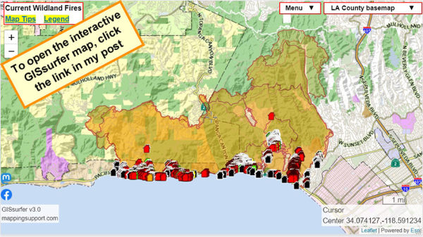
Tuesday 11:00 am. At the time of my post the #GIS layer with the damage assessment data for #PalisadesFire shows that 2,121 structures have been evaluated. Of those, 1,277 have been designated as destroyed (damage > 50%). Note that some of the evaluated structures are outside of the fire perimeter. #LAfires
To search on an address click Menu > Search.
Red - Destroyed > 50%
Orange - Major 26-50%
Yellow - Minor 10-25%
Green - Affected 1-9%
Black - No damage
White - Inaccessible
Open GISsurfer map:
https://mappingsupport.com/p2/gissurfer.php?center=34.074127,-118.591234&zoom=12&basemap=LA_County_basemap&overlay=Perimeter_FIRIS_intel,LA_County_map,LA_County_parcels,Palisades_damage_assessment&data=https://mappingsupport.com/p2/special_maps/disaster/USA_wildland_fire.txt
GISsurfer General Purpose Web Map and GIS Viewer | Surf GIS DATA
GISsurfer lets you surf a nearly endless amount of GIS data. Click a layer in the GIS server's table of contents and that data appears on the map.mappingsupport.com

