Zum Inhalt der Seite gehen

Suche

Beiträge, die mit franklinfire getaggt sind


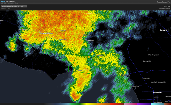
NWS has issued a Flash Flood Warning for Malibu and the PCH within and near the #PalisadesFire and #FranklinFire burn areas. Intense convective downpours will likely generate debris flows and/or flash flooding in some portions of the burn area shortly. #CAwx
Radar snapshot depicting flash flood warning region (green polygon).


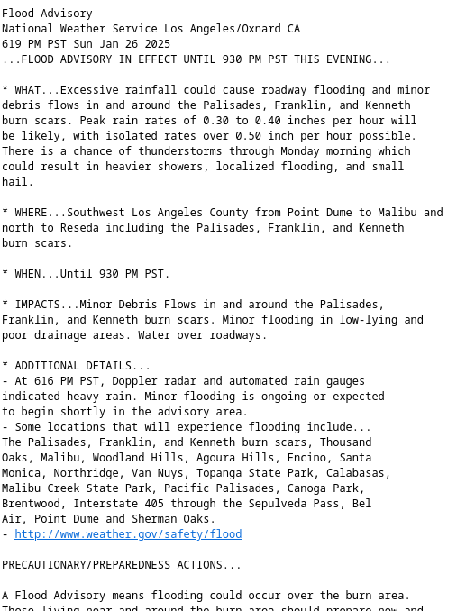
Flood Advisory
National Weather Service Los Angeles/Oxnard CA
619 PM PST Sun Jan 26 2025
...FLOOD ADVISORY IN EFFECT UNTIL 930 PM PST THIS EVENING...

* WHAT...Excessive rainfall could cause roadway flooding and minor debris flows in and around the Palisades, Franklin, and Kenneth burn scars. Peak rain rates of 0.30 to 0.40 inches per hour will be likely, with isolated rates over 0.50 inch per hour possible. There is a chance of thunderstorms through Monday morning which could result in heavier showers, localized flooding, and small
hail.

#CAwx #FloodAdvisory #PalisadesFire #FranklinFire #KennethFire
Flood Advisory
National Weather Service Los Angeles/Oxnard CA
619 PM PST Sun Jan 26 2025
...FLOOD ADVISORY IN EFFECT UNTIL 930 PM PST THIS EVENING...

* WHAT...Excessive rainfall could cause roadway flooding and minor
debris flows in and around the Palisades, Franklin, and Kenneth
burn scars. Peak rain rates of 0.30 to 0.40 inches per hour will
be likely, with isolated rates over 0.50 inch per hour possible.
There is a chance of thunderstorms through Monday morning which
could result in heavier showers, localized flooding, and small
hail.

* WHERE...Southwest Los Angeles County from Point Dume to Malibu and
north to Reseda including the Palisades, Franklin, and Kenneth
burn scars.

* WHEN...Until 930 PM PST.

* IMPACTS...Minor Debris Flows in and around the Palisades,
Franklin, and Kenneth burn scars. Minor flooding in low-lying and
poor drainage areas. Water over roadways.

* ADDITIONAL DETAILS...
- At 616 PM PST, Doppler radar and automated rain gauges
indicated heavy rain. Minor flooding is ongoing or expected
to begin shortly in the advisory area.
- Some locations that will experience flooding include...
The Palisades, Franklin, and Kenneth burn scars, Thousand
Oaks, Malibu, Woodland Hills, Agoura Hills, Encino, Santa
Monica, Northridge, Van Nuys, Topanga State Park, Calabasas,
Malibu Creek State Park, Pacific Palisades, Canoga Park,
Brentwood, Interstate 405 through the Sepulveda Pass, Bel
Air, Point Dume and Sherman Oaks.
- http://www.weather.gov/safety/flood


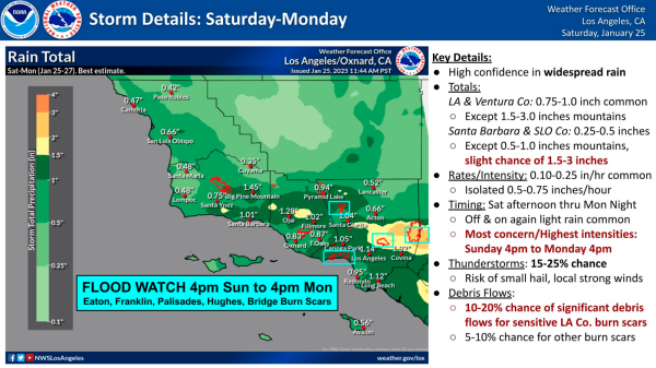
NWS Los Angeles/Oxnard Forecast for Sat-Mon (Jan 25-27)

FLOOD WATCH 4pm Sun to 4pm Mon Eaton, Palisades, Franklin, Hughes, Bridge Burn Scars

https://www.weather.gov/lox/

#CAwx #EatonFire #PalisadesFire #FranklinFire #HughesFire #BridgeFire
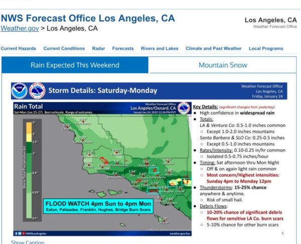
NWS LosAngeles/Oxnard infographic showing map of Southern California. Time stamped 24 Jan 2025; 12:36 pm PST 

Includes Key Details: (significant changes from yesterday)
• High confidence in widespread rain
• Totals:
LA & Ventura Co: 0.5-1.0 inches common
• Except 1.0-2.0 inches mountains
Santa Barbara & SLO Co: 0.25-0.5 inches
• Except 0.5-1.0 inches mountains
• Rates/Intensity: 0.10-0.25 in/hr common
• Isolated 0.5-0.75 inches/hour
• Timing: Sat afternoon thru Mon Night
• Off & on again light rain common
• Most concern/Highest intensities:
Sunday 4pm to Monday 12pm
• Thunderstorms: 15-25% chance anywhere & anytime.
• Risk of small hail.
• Debris Flows:
• 10-20% chance of significant debris flows for sensitive LA Co. burn scars
• 5-10% chance for other burn scars


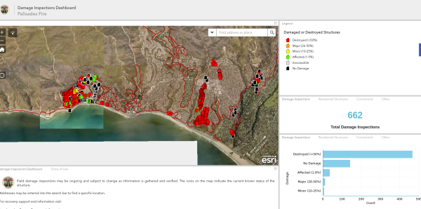
Official CALFIRE damage inspection map for the Palisades Fire as of 1/13/25 0618

(Note they have done 662 inspections, likely there are more than 5000 structures destroyed here in the Palisades Fire. This map also includes damage from the earlier Franklin Fire)

#PalisadesFire #PacificPalisades #Malibu #FranklinFire
Map with many red "destroyed" buildings on it