Suche
Beiträge, die mit CAwx getaggt sind


.")
National Weather Service Los Angeles/Oxnard CA
619 PM PST Sun Jan 26 2025
...FLOOD ADVISORY IN EFFECT UNTIL 930 PM PST THIS EVENING...
* WHAT...Excessive rainfall could cause roadway flooding and minor debris flows in and around the Palisades, Franklin, and Kenneth burn scars. Peak rain rates of 0.30 to 0.40 inches per hour will be likely, with isolated rates over 0.50 inch per hour possible. There is a chance of thunderstorms through Monday morning which could result in heavier showers, localized flooding, and small
hail.
#CAwx #FloodAdvisory #PalisadesFire #FranklinFire #KennethFire

FLOOD WATCH 4pm Sun to 4pm Mon Eaton, Palisades, Franklin, Hughes, Bridge Burn Scars
https://www.weather.gov/lox/
#CAwx #EatonFire #PalisadesFire #FranklinFire #HughesFire #BridgeFire

• High confidence in widespread rain
• Totals:
LA & Ventura Co: 0.5-1.0 inches common
• Except 1.0-2.0 inches mountains
Santa Barbara & SLO Co: 0.25-0.5 inches
• Except 0.5-1.0 inches mountains
• Rates/Intensity: 0.10-0.25 in/hr common
• Isolated 0.5-0.75 inches/hour
• Timing: Sat afternoon thru Mon Night
• Off & on again light rain common
• Most concern/Highest intensities:
Sunday 4pm to Monday 12pm
• Thunderstorms: 15-25% chance anywhere & anytime.
• Risk of small hail.
• Debris Flows:
• 10-20% chance of significant debris flows for sensitive LA Co. burn scars
• 5-10% chance for other burn scars")
Los Angeles, CA
NOAA National Weather Service Los Angeles, CAUS Department of Commerce, NOAA, National Weather Service
There is a potential storm expected to enter the region on Saturday, Jan. 25, and last through Monday, Jan. 27. The latest forecast calls for a quarter to a half inch of rain with 10-20% chance of thunderstorms. Call the Los Angeles County Public Works 24-hour Dispatch Center to report storm-related damage, traffic signal outages, flooding or other concerns at 1-800-675-HELP (4357).
#CAwx #storm #PalisadesFire #EatonFire
#HighWindWarning - Diagonals
#RedFlagWarning - Red
For official details from NOAA including timing, open the map, zoom in, click in red area. Scroll down in the popup that appears since there might be multiple weather watches/warnings for the spot you clicked and each one has its own link to the details.
#LAfires #SantaAnna #CAfire #CAwx #Wildfire
Open GISsurfer map:
https://mappingsupport.com/p2/gissurfer.php?center=33.845506,-118.025818&zoom=8&basemap=USA_basemap&overlay=State_boundary,High_wind_warning,Red_flag_warning&data=https://mappingsupport.com/p2/special_maps/disaster/USA_wildland_fire.txt


GISsurfer General Purpose Web Map and GIS Viewer | Surf GIS DATA
GISsurfer lets you surf a nearly endless amount of GIS data. Click a layer in the GIS server's table of contents and that data appears on the map.mappingsupport.com
NIFC New Or Updated Wildfire Perimeter
Incident Name: PALISADES
Acres: 23448.0 acres
Updated: Jan 21, 2025 23:43 UTC
Source: IRWIN
#PALISADESFire #CAwx

Normal red flag warning starts 8am Monday.
PDS red flag warning starts noon Monday.
Same scenario as when Palisades and Eaton fires started.
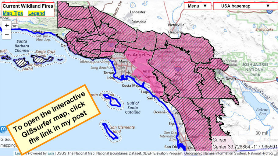
Map legend:
#HighWindWarning - Diagonals
#RedFlagWarning - Red
For official details from NOAA including timing, open the map, zoom in, click in red area. Scroll down in the popup that appears since there might be multiple weather watches/warnings for the spot you clicked and each one has its own link to the details.
#LAfires #SantaAnna #CAfire #CAwx #Wildfire
Open GISsurfer map:
https://mappingsupport.com/p2/gissurfer.php?center=33.726864,-117.965591&zoom=8&basemap=USA_basemap&overlay=State_boundary,High_wind_warning,Red_flag_warning&data=https://mappingsupport.com/p2/special_maps/disaster/USA_wildland_fire.txt


GISsurfer General Purpose Web Map and GIS Viewer | Surf GIS DATA
GISsurfer lets you surf a nearly endless amount of GIS data. Click a layer in the GIS server's table of contents and that data appears on the map.mappingsupport.com

#RedFlagWarning - Red
For official details from NOAA including timing, open the map, zoom in, click in red area. Scroll down in the popup that appears since there might be multiple weather watches/warnings for the spot you clicked and each one has its own link to the details.
#LAfires #SantaAnna #CAfire #CAwx #Wildfire
Open GISsurfer map:
https://mappingsupport.com/p2/gissurfer.php?center=33.726864,-117.965591&zoom=8&basemap=USA_basemap&overlay=State_boundary,High_wind_warning,Red_flag_warning&data=https://mappingsupport.com/p2/special_maps/disaster/USA_wildland_fire.txt
GISsurfer General Purpose Web Map and GIS Viewer | Surf GIS DATA
GISsurfer lets you surf a nearly endless amount of GIS data. Click a layer in the GIS server's table of contents and that data appears on the map.mappingsupport.com
This map always shows NOAA’s “Fire Weather Outlooks” for the following day. At the time of my post, that would be Monday.
There are three levels based on forecasts for wind and humidity. NOAA designates those levels as Elevated, Critical and Extreme. On this map the area classified as Extreme is purple.
#LAfires #SantaAnna #CAfire #CAwx #Wildfire
Open GISsurfer map:
https://mappingsupport.com/p2/gissurfer.php?center=34.172874,-118.317394&zoom=8&basemap=USA_basemap&overlay=State_boundary,County_boundary,Lake_river_stream,USA_roads,Fire_weather_day_2&data=https://mappingsupport.com/p2/special_maps/disaster/USA_wildland_fire.txt
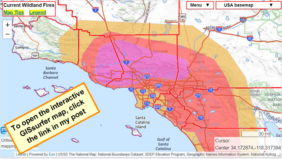
GISsurfer General Purpose Web Map and GIS Viewer | Surf GIS DATA
GISsurfer lets you surf a nearly endless amount of GIS data. Click a layer in the GIS server's table of contents and that data appears on the map.mappingsupport.com
Southern California Geographic Area Coordination Center
January 16-30, 2025
“The resultant level of fuel volatility would be notable in summer months, and is extraordinary for January.”
Open PDF file: (2 pages)
https://www.nifc.gov/sites/default/files/NICC/2-Predictive%20Services/Fuels-Fire%20Danger/Fuels-Fire-Behavior-Advisory_OSC_20250116.pdf
#CAfire #CAwx #LAFires #CalFire #CalOES #NOAA


Here's one of the biggest contributors: the extreme dryness
Good graphics/explanations/etc. from the NDMC Drought Center
https://mastodon.world/@droughtcenter/113839032448072201
#wildfires #CAwx #EatonFire #PalisadesFire
")
Drought Center (@droughtcenter@mastodon.world)
Attached: 1 image Severe drought expanded in southern California over the past week, as the destructive wildfires in Los Angeles continue. The Los Angeles area has seen very dry conditions since the beginning of the water year (Oct. 1, 2024).Mastodon


Weather and climate office hours by Weather West: 01/15/25 topic: SoCal fires plus upcoming weather
The latest in a recurring series of live, virtual, & interactive "office hours" hosted by Dr. Daniel Swain on various topics related to extreme weather and c...YouTube
Los Angeles County Disaster Recovery Centers Are Open for Hurricane-Force Firestorm Survivors
Published: Jan 13, 2025
California Governor’s Office of Emergency Services (Cal OES), Federal Emergency Management Agency (FEMA) and the County of Los Angeles along with other state and local partners, are opening two Disaster Recovery Centers (DRC) in Los Angeles County on Tuesday, January 14th at 1:00pm.
#wildfires #CAwx #LosAngeles #EatonFire #PalisadesFire https://news.caloes.ca.gov/los-angeles-county-disaster-recovery-centers-open-tuesday-for-hurricane-force-firestorm-survivors/
Katlyn C, Staff Reporter
Jan 13 at 7:13 PM EST
Zones PAS-E019, PAS-E022-A, and KIN-KINNELOA-B have been reduced to Evacuation Warning from its previous order status.
For the zones' parameters, see the Watch Duty Map or Genasys Protect.
https://protect.genasys.com/zones/US-CA-XLA-PAS-E006?z=11.752913285409358&latlon=34.19002055190569%2C-118.17391391690296
https://share.watchduty.org/i/40388?ts=1736813584000

Watch Duty - Wildfire Maps & Alerts
Real-time information about wildfire and firefighting efforts nearbyWatch Duty
Katlyn C, Staff Reporter
Jan 13 at 7:00 PM EST
Eaton Fire - Community Meeting 01.13.25 provided by the Los Angeles County Fire Department
https://www.youtube.com/live/UJFaSFXhwkc?feature=shared
https://share.watchduty.org/i/40388?ts=1736813584000

Watch Duty - Wildfire Maps & Alerts
Real-time information about wildfire and firefighting efforts nearbyWatch Duty
NIFC New Or Updated Wildfire Perimeter
Incident Name: PALISADES
Acres: 23461.4 acres
Updated: Jan 13, 2025 22:56 UTC
Source: IRWIN
#PALISADESFire #CAwx

Katlyn C, Staff Reporter
Jan 13 at 6:42 PM EST
Two VLATs (very-large air tankers) and six Type-1 LATs (large air tankers) have been requested to the incident per air attack.
https://share.watchduty.org/i/40388?ts=1736811760000

Watch Duty - Wildfire Maps & Alerts
Real-time information about wildfire and firefighting efforts nearbyWatch Duty

Weather and climate office hours: 01/13/2025 topic: Coverage of SoCal wildfires & new wind event
The latest in a recurring series of live, virtual, & interactive "office hours" hosted by Dr. Daniel Swain on various topics related to extreme weather and c...YouTube
1/6
Don Zirbel, Staff Reporter
Jan 13 at 10:44 AM
Eaton Fire Update from the Incident Management Team - January 13, 2025, 7:00am
Total Assigned Personnel: 3,408
Virtual Community Meeting Monday, January 13th 4:00 p.m.: Eaton Fire officials will host a virtual community meeting to provide the current fire situation, address questions, and discuss recovery. The meeting will be streamed live on YouTube: https://www.youtube.com/@LosAngelesCountyFD. A question-and-answer session will follow the presentation. Please submit your questions in advance via email at 2025.eaton@firenet.gov.

Los Angeles County Fire Department
Welcome to the official YouTube Channel of the Los Angeles County Fire Department. We are a highly responsive team of over 4,300 firefighters, lifeguards, haz-mat specialists, foresters, helicopter pilots, dozer operators and business professional…YouTube
Don Zirbel, Staff Reporter
Jan 13 at 8:55 AM EST
The fire is now 33% contained, per the National Interagency Fire Center (NIFC).
https://share.watchduty.org/i/40388?ts=1736776509000

Watch Duty - Wildfire Maps & Alerts
Real-time information about wildfire and firefighting efforts nearbyWatch Duty
NIFC New Or Updated Wildfire Perimeter
Incident Name: PALISADES
Acres: 23465.4 acres
Updated: Jan 13, 2025 04:23 UTC
Source: IRWIN
#PALISADESFire #CAwx

NIFC New Or Updated Wildfire Perimeter
Incident Name: PALISADES
Acres: 23465.4 acres
Updated: Jan 13, 2025 04:23 UTC
Source: IRWIN
#PALISADESFire #CAwx

Katlyn C, Staff Reporter
Jan 12 at 6:21 PM EST
Evacuation orders have been downgraded to now be evacuation Warnings in Zones: ARC-001, SMD-E001, SMD-E002, SMD-E003, SMD-E004, SMD-E005, SMD-E006, SMD-E007, SMD-E008, SMD-E009, SMD-E010, SMD-E011, SMD-E012, SMD-E013, SMD-E014, SMD-E015, SMD-E016, SMD-E019
Evacuations have been lifted from ARC-002 and ARC-004.
To view the Zone changes, see the Watch Duty Map or Genasys Protect.
Additionally, Zone ALD-GARFIAS has been downgraded from an order to now be a warning per Los Angeles County Sheriff's Department, though this update has not yet been reflected in Genasys Protect.
https://protect.genasys.com/fullscreenMap?z=10.895931700630474&latlon=34.07816579843218%2C-118.61514229579961
https://share.watchduty.org/i/40388?ts=1736724103000

Watch Duty - Wildfire Maps & Alerts
Real-time information about wildfire and firefighting efforts nearbyWatch Duty
From The Los Angeles Times: Aerial assault keeps flames from invading Brentwood, Encino but more winds coming
https://www.latimes.com/california/live/2025-01-10/fire-los-angeles-california-eaton-palisades-updates


NIFC New Or Updated Wildfire Perimeter
Incident Name: PALISADES
Acres: 23508.0 acres
Updated: Jan 12, 2025 06:40 UTC
Source: IRWIN
#PALISADESFire #CAwx


NIFC New Or Updated Wildfire Perimeter
Incident Name: PALISADES
Acres: 23440.4 acres
Updated: Jan 12, 2025 04:19 UTC
Source: IRWIN
#PALISADESFire #CAwx


