Suche
Beiträge, die mit SantaAnna getaggt sind
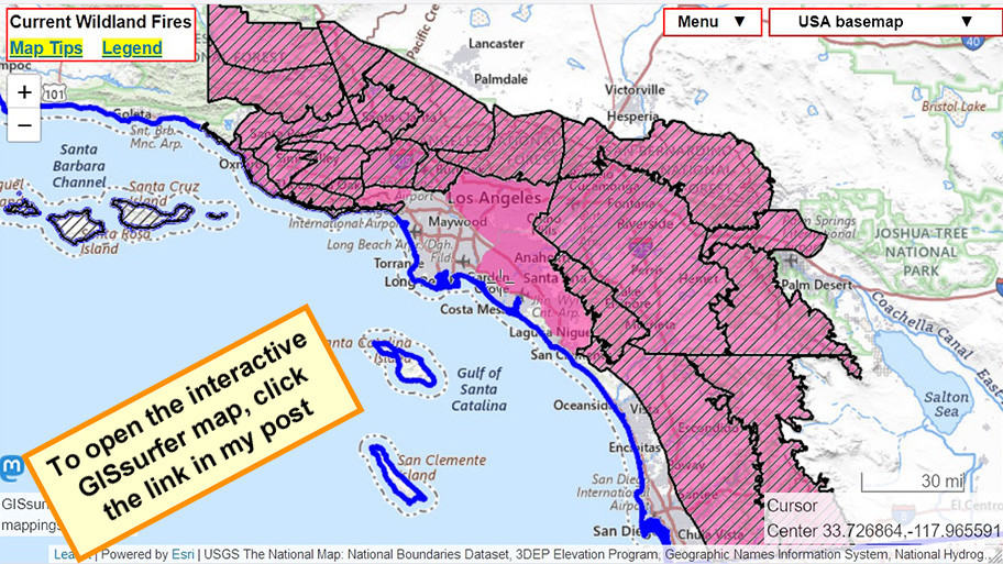
#HighWindWarning - Diagonals
#RedFlagWarning - Red
For official details from NOAA including timing, open the map, zoom in, click in red area. Scroll down in the popup that appears since there might be multiple weather watches/warnings for the spot you clicked and each one has its own link to the details.
#LAfires #SantaAnna #CAfire #CAwx #Wildfire
Open GISsurfer map:
https://mappingsupport.com/p2/gissurfer.php?center=33.845506,-118.025818&zoom=8&basemap=USA_basemap&overlay=State_boundary,High_wind_warning,Red_flag_warning&data=https://mappingsupport.com/p2/special_maps/disaster/USA_wildland_fire.txt


GISsurfer General Purpose Web Map and GIS Viewer | Surf GIS DATA
GISsurfer lets you surf a nearly endless amount of GIS data. Click a layer in the GIS server's table of contents and that data appears on the map.mappingsupport.com

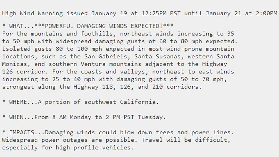
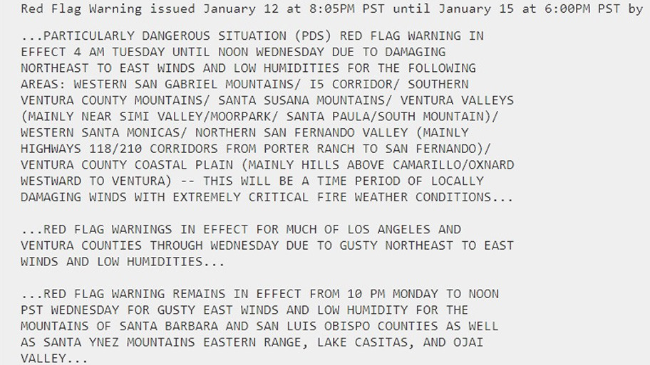
Normal red flag warning starts 8am Monday.
PDS red flag warning starts noon Monday.
Same scenario as when Palisades and Eaton fires started.
Map legend:
#HighWindWarning - Diagonals
#RedFlagWarning - Red
For official details from NOAA including timing, open the map, zoom in, click in red area. Scroll down in the popup that appears since there might be multiple weather watches/warnings for the spot you clicked and each one has its own link to the details.
#LAfires #SantaAnna #CAfire #CAwx #Wildfire
Open GISsurfer map:
https://mappingsupport.com/p2/gissurfer.php?center=33.726864,-117.965591&zoom=8&basemap=USA_basemap&overlay=State_boundary,High_wind_warning,Red_flag_warning&data=https://mappingsupport.com/p2/special_maps/disaster/USA_wildland_fire.txt


GISsurfer General Purpose Web Map and GIS Viewer | Surf GIS DATA
GISsurfer lets you surf a nearly endless amount of GIS data. Click a layer in the GIS server's table of contents and that data appears on the map.mappingsupport.com
#RedFlagWarning - Red
For official details from NOAA including timing, open the map, zoom in, click in red area. Scroll down in the popup that appears since there might be multiple weather watches/warnings for the spot you clicked and each one has its own link to the details.
#LAfires #SantaAnna #CAfire #CAwx #Wildfire
Open GISsurfer map:
https://mappingsupport.com/p2/gissurfer.php?center=33.726864,-117.965591&zoom=8&basemap=USA_basemap&overlay=State_boundary,High_wind_warning,Red_flag_warning&data=https://mappingsupport.com/p2/special_maps/disaster/USA_wildland_fire.txt
GISsurfer General Purpose Web Map and GIS Viewer | Surf GIS DATA
GISsurfer lets you surf a nearly endless amount of GIS data. Click a layer in the GIS server's table of contents and that data appears on the map.mappingsupport.com
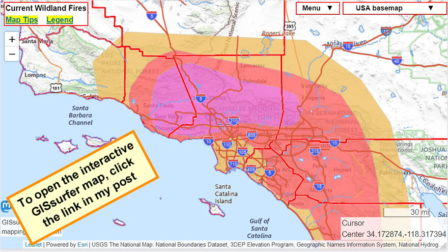
This map always shows NOAA’s “Fire Weather Outlooks” for the following day. At the time of my post, that would be Monday.
There are three levels based on forecasts for wind and humidity. NOAA designates those levels as Elevated, Critical and Extreme. On this map the area classified as Extreme is purple.
#LAfires #SantaAnna #CAfire #CAwx #Wildfire
Open GISsurfer map:
https://mappingsupport.com/p2/gissurfer.php?center=34.172874,-118.317394&zoom=8&basemap=USA_basemap&overlay=State_boundary,County_boundary,Lake_river_stream,USA_roads,Fire_weather_day_2&data=https://mappingsupport.com/p2/special_maps/disaster/USA_wildland_fire.txt
GISsurfer General Purpose Web Map and GIS Viewer | Surf GIS DATA
GISsurfer lets you surf a nearly endless amount of GIS data. Click a layer in the GIS server's table of contents and that data appears on the map.mappingsupport.com
To search on an address click Menu > Search.
For official details from NOAA including timing, open the map, zoom in, click in red area. Scroll down in the popup that appears since there might be multiple weather watches/warnings for the spot you clicked and each one has its own link to the details.
#PalisadesFire #EatonFire #LAfires #SantaAnna
Open GISsurfer map:
https://mappingsupport.com/p2/gissurfer.php?center=34.358120,-118.633138&zoom=9&basemap=USA_basemap&overlay=MODIS_7_day,VIIRS_7_day,Perimeter_FIRIS_intel,High_wind_warning,Red_flag_warning&data=https://mappingsupport.com/p2/special_maps/disaster/USA_wildland_fire.txt
GISsurfer General Purpose Web Map and GIS Viewer | Surf GIS DATA
GISsurfer lets you surf a nearly endless amount of GIS data. Click a layer in the GIS server's table of contents and that data appears on the map.mappingsupport.com
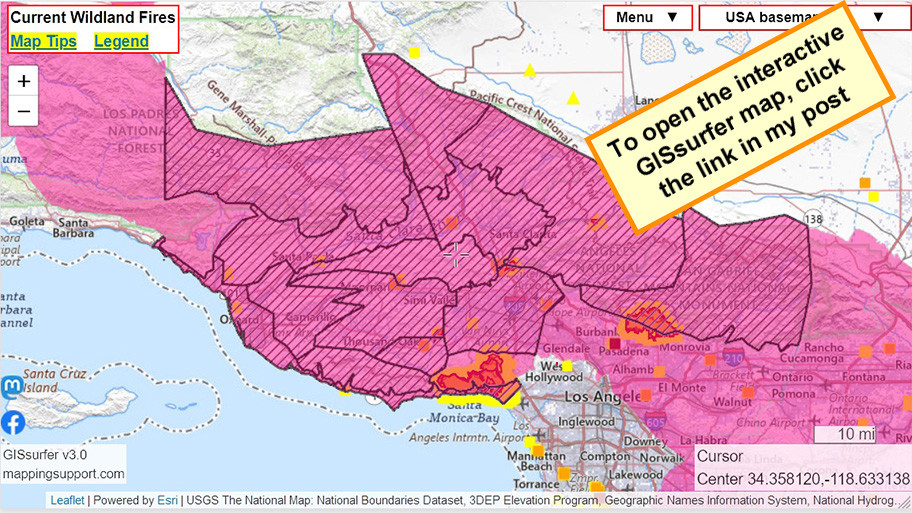
#RedFlagWarning (red).
#HighWindWarning (diagonals).
For official details from NOAA including timing, open the map, zoom in, click in red area. Scroll down in the popup that appears since there might be multiple weather watches/warnings for the spot you clicked and each one has its own link to the details.
#PalisadesFire #EatonFire #LAfires #SantaAnna
Open GISsurfer map:
https://mappingsupport.com/p2/gissurfer.php?center=33.963875,-118.592112&zoom=8&basemap=USA_basemap&overlay=MODIS_7_day,VIIRS_7_day,Perimeter_FIRIS_intel,High_wind_warning,Red_flag_warning&data=https://mappingsupport.com/p2/special_maps/disaster/USA_wildland_fire.txt
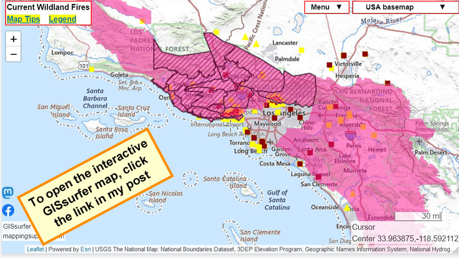
GISsurfer General Purpose Web Map and GIS Viewer | Surf GIS DATA
GISsurfer lets you surf a nearly endless amount of GIS data. Click a layer in the GIS server's table of contents and that data appears on the map.mappingsupport.com