Suche
Beiträge, die mit Palisadesfire getaggt sind
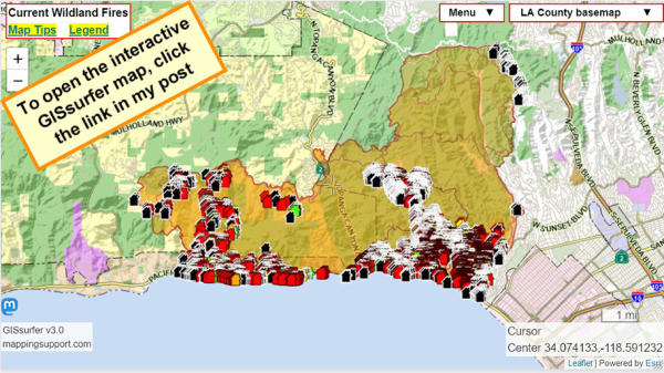
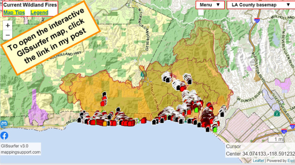
To search on an address click Menu > Search.
Red - Destroyed > 50%
Orange - Major 26-50%
Yellow - Minor 10-25%
Green - Affected 1-9%
Black - No damage
White - Inaccessible
Open GISsurfer map:
https://mappingsupport.com/p2/gissurfer.php?center=34.074127,-118.591234&zoom=12&basemap=LA_County_basemap&overlay=Perimeter_FIRIS_intel,LA_County_map,LA_County_parcels,Palisades_damage_assessment&data=https://mappingsupport.com/p2/special_maps/disaster/USA_wildland_fire.txt
GISsurfer General Purpose Web Map and GIS Viewer | Surf GIS DATA
GISsurfer lets you surf a nearly endless amount of GIS data. Click a layer in the GIS server's table of contents and that data appears on the map.mappingsupport.com
"My mom used to say, if you don’t have something nice to say, don’t say anything.…I feel like that goes double in a crisis."
https://www.instagram.com/p/DEvVWglqf1e/
#LosAngelesFire #LosAngeles
Los Angeles Braces For Another Santa Ana Event With Gusts To 100 MPH - EUROPE SAYS
As residents impacted by the Eaton and Palisades Fires were slowly returning to their homes — or whereEUROPE SAYS (EUROPESAYS.COM)
UPDATE 1/19 1:00 PM: Palisades Fire 23,713 acres, 52% containment; N95 mask distribution at Bluffs Park 9 AM- 4 PM. DRC open for MLK holiday, Jan 20, 9 AM- 8 PM
Size: 23,713 acres
Containment: 52%
Structures: CalFire confirmed 4,996 structures destroyed and 707 damaged in total affected
palisades-fire/
Injuries: 3*
Fatalities: 3 in Malibu (LA County Medical Examiner), 10 total (CalFire)
Missing: 6 (LA County Sheriff)
https://www.malibucity.org/AlertCenter.aspx?AID=3400
#PalisadesFire #Malibu #wildfires
Spencer Pratt Reveals How Much He Earned on TikTok After Losing Home
Spencer Pratt Reveals How Much He Earned on TikTok After Losing Home - INBELLAINBELLA
https://energized.edison.com/extreme-weather-restoration-update
#SCE #PSPS #EatonFire #PalisadesFire
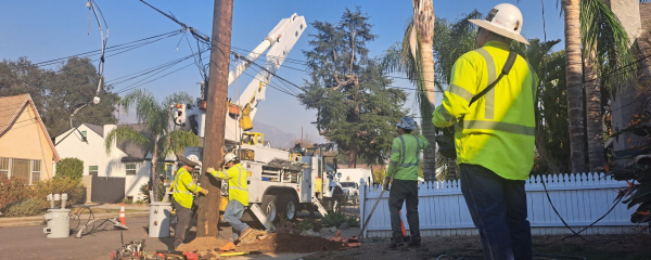
Extreme Weather Restoration Update
Extreme Weather Event Important SCE Service Notice for Impacted CustomersEnergized by Edison
The first evacuation order covering neighborhoods closest to the start of the devastating Pacific Palisades wildfire didn’t come until about 40 minutes after some of those homes were already burning, according to an Associated Press analysis of emergency communications and interviews with survivors
https://www.pbs.org/newshour/nation/homes-were-burning-and-roads-jammed-before-evacuation-order-for-palisades-fire-ap-finds
#PalisadesFire

Homes were burning and roads jammed before evacuation order for Palisades Fire, AP finds
The first evacuation order covering neighborhoods closest to the start of the devastating Pacific Palisades wildfire didn’t come until about 40 minutes after some of those homes were already burning, according to an Associated Press analysis of emerg…PBS News
VLAT action explained
https://www.instagram.com/p/DEskd4No299/
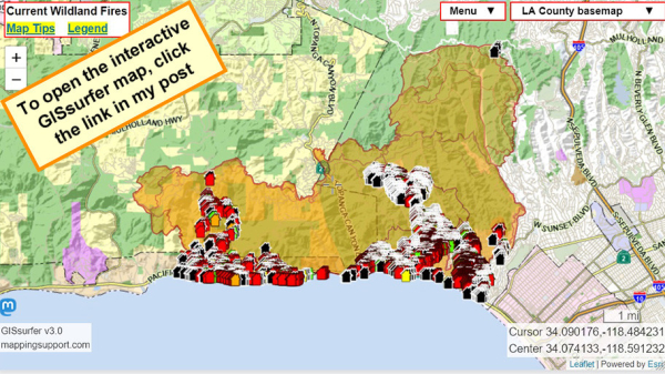
To search on an address click Menu > Search.
Red - Destroyed > 50%
Orange - Major 26-50%
Yellow - Minor 10-25%
Green - Affected 1-9%
Black - No damage
White - Inaccessible
Open GISsurfer map:
https://mappingsupport.com/p2/gissurfer.php?center=34.074127,-118.591234&zoom=12&basemap=LA_County_basemap&overlay=Perimeter_FIRIS_intel,LA_County_map,LA_County_parcels,Palisades_damage_assessment&data=https://mappingsupport.com/p2/special_maps/disaster/USA_wildland_fire.txt
GISsurfer General Purpose Web Map and GIS Viewer | Surf GIS DATA
GISsurfer lets you surf a nearly endless amount of GIS data. Click a layer in the GIS server's table of contents and that data appears on the map.mappingsupport.com
UPDATE 1/17/25 6:30 PM: Palisades Fire remains at 23,713 acres with 31% containment.
CalFire estimates approximately 5,000 structures damaged or destroyed. 3,501 structures confirmed destroyed and 603 damaged in total effected area (Palisades and Malibu). Damage assessments continue to determine how many homes are part of the estimated damaged structures.
https://www.malibucity.org/AlertCenter.aspx?AID=3400
#PalisadesFire
#PalisadesFire 27% contained
Deaths 10
Damage Assessment (50%)
Structures damaged 591
Structures destroyed 3 328
#EatonFire 55% contained
Deaths 17
Damage Assessment (70%)
Structures damaged 773
Structures destroyed 6,782
The Los Angeles County Sheriff’s Department sent an urgent message out to patrol cars Wednesday afternoon, warning deputies in Altadena that, after days of nearby wildfires, the air is so toxic they should wear masks and decontaminate their uniforms before stepping foot in their homes.
Sent at 4:35 p.m., the message began “**Attn all personnel**” and said that the Los Angeles County Fire Department’s hazmat team reported the air in Altadena is “‘hazardous, containing lead, asbestos and other harmful particulates.”
(more...)
https://www.latimes.com/california/story/2025-01-16/deputies-warned-to-decontaminate-clothes-after-lead-asbestos-found-in-air-near-eaton-fire?utm_source=flipboard&utm_medium=activitypub
#EatonFire #PalisadesFire #hazmat
Lineup for the FireAid benefit concert, set up to aid relief efforts following the deadly #LosAngeles #wildfires ....https://fireaidla.org/
Homepage - FireAid
Join us for an evening of music and solidarity. The FireAid benefit concert will be held at Intuit Dome on January 30th dedicated to rebuilding communities that have been devastated by wildfires.FireAid
https://www.youtube.com/watch?v=49COW4dev7E
- YouTube
Auf YouTube findest du die angesagtesten Videos und Tracks. Außerdem kannst du eigene Inhalte hochladen und mit Freunden oder gleich der ganzen Welt teilen.www.youtube.com
Evacuation Order and Evacuation Warning Changes for the Palisades Fire; 02:10P
https://lafd.org/alert/evacuation-order-and-evacuation-warning-changes-palisades-fire-01162025
#EatonFire
Deads: 16
Injuries: 6 (firefighters)
Missing: 24
#PalisadesFire
Deads: 9
Injuries: 6 (3 civilians + 3 firefighters)
Missing: 7
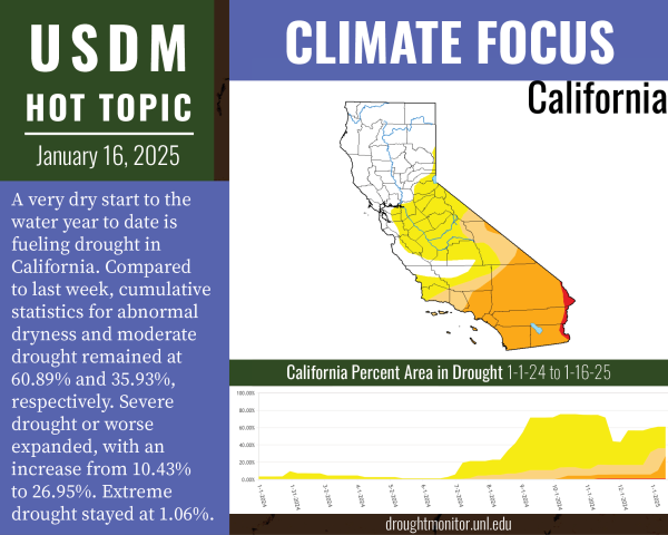
Here's one of the biggest contributors: the extreme dryness
Good graphics/explanations/etc. from the NDMC Drought Center
https://mastodon.world/@droughtcenter/113839032448072201
#wildfires #CAwx #EatonFire #PalisadesFire
Drought Center (@droughtcenter@mastodon.world)
Attached: 1 image Severe drought expanded in southern California over the past week, as the destructive wildfires in Los Angeles continue. The Los Angeles area has seen very dry conditions since the beginning of the water year (Oct. 1, 2024).Mastodon
To search on an address click Menu > Search.
Red - Destroyed > 50%
Orange - Major 26-50%
Yellow - Minor 10-25%
Green - Affected 1-9%
Black - No damage
White - Inaccessible
Open GISsurfer map:
https://mappingsupport.com/p2/gissurfer.php?center=34.074127,-118.591234&zoom=12&basemap=LA_County_basemap&overlay=Perimeter_FIRIS_intel,LA_County_map,LA_County_parcels,Palisades_damage_assessment&data=https://mappingsupport.com/p2/special_maps/disaster/USA_wildland_fire.txt
GISsurfer General Purpose Web Map and GIS Viewer | Surf GIS DATA
GISsurfer lets you surf a nearly endless amount of GIS data. Click a layer in the GIS server's table of contents and that data appears on the map.mappingsupport.com
1/16/25 0713
#EatonFire #PalisadesFire #FireWx #LosAngeles #disaster #LAFires2025
UPDATE 1/15, 6:30 PM: Palisades Fire 19% contained. Additional SCE circuits re-energized. Call (213) 270-8155 for missing animals in evac area
https://www.malibucity.org/AlertCenter.aspx?AID=3393

UPDATE 1/10, 4:00 PM: The Palisades Fire has now burned 21,317 acres with 8% containment. No one allowed into evac area; night time Curfew in effect
UPDATE 1/10, 4:00 PM: The Palisades Fire has now burned 21,317 acres, 8% contained. Winds have improved, but situation remains dangerous. No one is allowed into mandatory evacuated areas. Night time Curfew in effect 6PM-6AM.Malibu, CA
Still not enough.
#albuquerque #losangeles #palisadesfire #altadena #eatonfire #blackmastodon #latinomastodon #BrownMastodon https://www.koat.com/article/abq-media-holds-donation-drive-for-los-angeles-wildfire-victims-koat/63435483
For residents evacuated within the City of LA, please call (213) 270-8155 and a care team will provide assistance. If you found a pet or if you lost a pet, please visit PetCo Love Lost System.
https://petcolove.org/lost/?utm_campaign=lost-evergreen&utm_content=&utm_medium=email&utm_name=&utm_source=govdelivery&utm_term=
#PalisadesFire #LACity #pets
Report and Search Lost and Found Pets | Petco Love Lost
Petco Love Lost uses facial recognition software to report or search for lost dogs and lost cats nationwide. It's free and easy to use.Petco Love Lost
To be considered for the program, residents need to first apply to 211 LA for housing assistance
Residents who have already applied through 211 LA do not to need to fill out another application.
Application link here:
https://docs.google.com/forms/d/e/1FAIpQLSeffO_8LNOoB-LEwdNHBg6pq6Le3bicFMSmxKUb-JZhaHBJyg/viewform
#EatonFire #PalisadesFire #housing #LACounty #LACity
Emergency Services Request
Support for Those Affected by the Greater Los Angeles Wildfires Our hearts go out to everyone impacted by the devastating wildfires across Greater Los Angeles. If you have been affected, you may be eligible for Emergency Services.Google Docs
#Malibu resident Joseph Church returned to find his home -- and his classic 1965 Porsche -- destroyed by the #PalisadesFire.
https://abc7.com/post/southern-california-wildfire-malibu-resident-returns-find-home-1965-porsche-destroyed-palisades-fire/15803238/
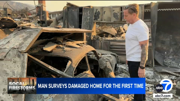
Malibu resident returns to find his home and 1965 Porsche destroyed by Palisades Fire
Malibu resident Joseph Church returned to find his home -- and his classic 1965 Porsche -- destroyed by the Palisades Fire.Michelle Fisher (ABC7 Los Angeles)
UPDATE 1/15, 4:00 PM: Palisades Fire 19% contained. CalFire Community Meeting Jan 16, 6:30 PM. Call (213) 270-8155 for missing animals in evacuation area.
Current Fire Status (source: CalFire):
Size: 23,713 acres
Containment: 19%
Structures: CalFire estimates approximately 5,000 structures damaged or destroyed. 2,191 structures confirmed destroyed in total effected area (Palisades and Malibu).
https://www.malibucity.org/AlertCenter.aspx?AID=3393
#PalisadesFire #Malibu #PacificPalisades

UPDATE 1/10, 4:00 PM: The Palisades Fire has now burned 21,317 acres with 8% containment. No one allowed into evac area; night time Curfew in effect
UPDATE 1/10, 4:00 PM: The Palisades Fire has now burned 21,317 acres, 8% contained. Winds have improved, but situation remains dangerous. No one is allowed into mandatory evacuated areas. Night time Curfew in effect 6PM-6AM.Malibu, CA
#palisadesfire
https://m.ai6yr.org/@calfire_bot/113833907321759947
CALFIRE bot (@calfire_bot@m.ai6yr.org)
Southern California Fire Activity Update Jan. 15 #palisadesfire #Eatonfire #calfirefirefighters #calfire https://www.youtube.com/watch?v=ZTKf_aHFC5MAI6YR's Mastodon
