Suche
Beiträge, die mit PalisadesFIre getaggt sind
Sharon Stone and Halle Berry Support Boutique +COOP’s Fire Relief Efforts
Sharon Stone and Halle Berry Support Boutique +COOP's Fire Relief Efforts - INBELLAINBELLA
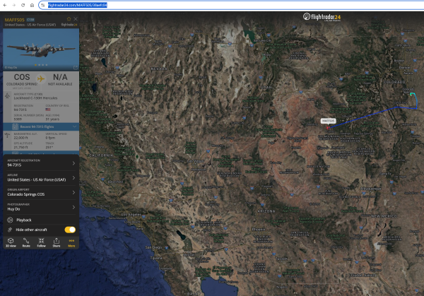
Live Flight Tracker - Real-Time Flight Tracker Map | Flightradar24
View flight on Flightradar24Flightradar24
The LA LGBT Center will be holding a donation drive for the wildfires on the 12th! If you can please bring anything you can spare, requested items can be found here: https://lalgbtcenter.org/vanguard/calling-all-angelenos-la-wildfire-relief-drive-this-sunday-jan-12/
#PalisadesFire #PasadenaFire #hurstfire #la #losangeles #sylmarfire #eatonfire #lafires #losangelesfire #hollywood #hollywoodfire #sunsetfire #wildfires #lgbt #lgbtq #lalgbt
- YouTube
Auf YouTube findest du die angesagtesten Videos und Tracks. Außerdem kannst du eigene Inhalte hochladen und mit Freunden oder gleich der ganzen Welt teilen.www.youtube.com
Family Assistance Center
2551 Motor Ave, Los Angeles, CA 90064
(310) 837-5286
The Cheviot Hills location is operated by LA City, and Los Angeles Police officers will be present to take missing persons reports. The Mayor’s Crisis Response Team, American Red Cross, LA County Medical Examiner’s Office, and LA County Department of Mental Health will provide additional information and support. For more information on missing loved ones, please call (800) 675-5799 or visit the Red Cross https://www.redcross.org/get-help/disaster-relief-and-recovery-services/contact-and-locate-loved-ones/california-wildfires-reunification.html

California Wildfires Reunification
If you need assistance locating or connecting with a loved one in California because of the wildfires the Red Cross may be able to help.www.redcross.org
People who continue to fly drones risk a prison sentence of up to 12 months or a fine of up to $75,000.
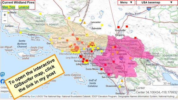
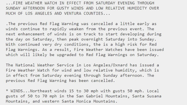
Light tan area = Fire Weather Watch. Includes #PalisadesFire
The ‘watch’ layer is ‘on top’ and can be clicked to see attribute data. Follow the link for details from NOAA.
To get the most benefit from the map see 2 links upper left corner.
Open GISsurfer map:
https://mappingsupport.com/p2/gissurfer.php?center=34.100296,-118.179932&zoom=8&basemap=USA_basemap&overlay=MODIS_7_day,VIIRS_7_day,Perimeter_FIRIS_intel,Red_flag_warning,Fire_Weather_Watch&data=https://mappingsupport.com/p2/special_maps/disaster/USA_wildland_fire.txt
GISsurfer General Purpose Web Map and GIS Viewer | Surf GIS DATA
GISsurfer lets you surf a nearly endless amount of GIS data. Click a layer in the GIS server's table of contents and that data appears on the map.mappingsupport.com
Pod Save America
Podcast · Crooked Media · Pod Save America is a no-bullshit conversation about politics hosted by former Obama aides Jon Favreau, Jon Lovett, Dan Pfeiffer, and Tommy Vietor.Spotify
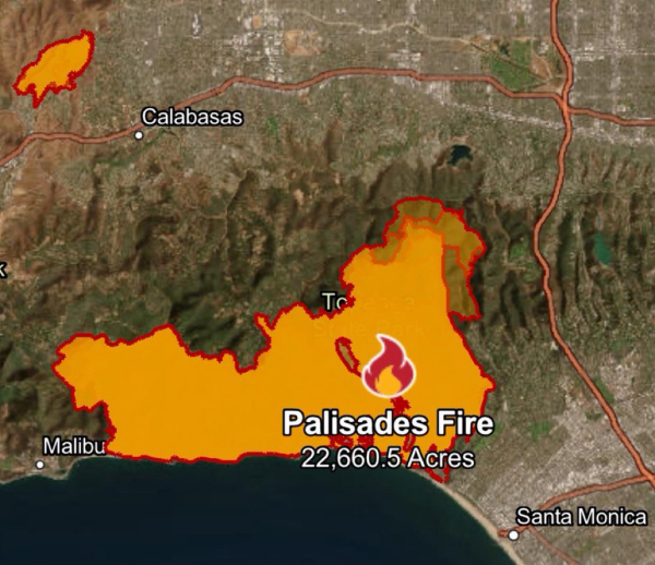
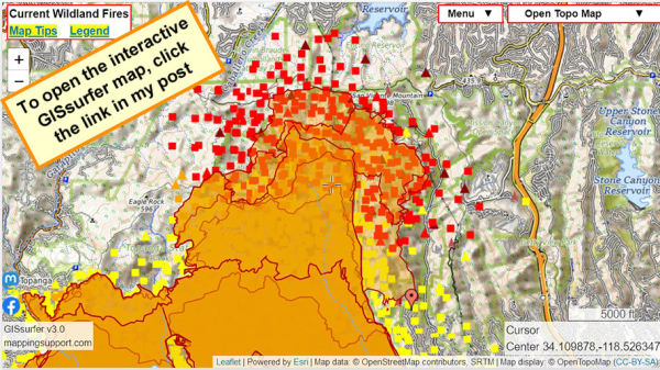
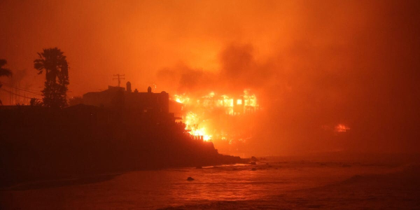
Map shows updated perimeter. Now at 22,660 acres.
Open GISsurfer map:
https://mappingsupport.com/p2/gissurfer.php?center=34.109878,-118.526347&zoom=13&basemap=Open_Topo_Map&overlay=MODIS_7_day,VIIRS_7_day,Fire_camera_location,Perimeter_FIRIS_intel,Lake_river_stream&data=https://mappingsupport.com/p2/special_maps/disaster/USA_wildland_fire.txt||34.084767,-118.507161
GISsurfer General Purpose Web Map and GIS Viewer | Surf GIS DATA
GISsurfer lets you surf a nearly endless amount of GIS data. Click a layer in the GIS server's table of contents and that data appears on the map.mappingsupport.com
The fire burnt through what was reputed as a Nazi hideout in the Los Angeles Hills, Murphy Ranch:
Curbed: What really happened at Rustic Canyon’s rumored Nazi ranch?
Rumors abound about the ruins in Pacific Palisades. Here’s the true history
"Herr Schmidt warned that Germany would soon defeat the United States and that the end of the world was at hand. Whether Schmidt foresaw this outcome with his “mystical powers” or by his association with the fascist, increasingly bellicose government in Germany is unclear."
https://la.curbed.com/2014/9/24/10043624/murphy-ranch-trail-pacific-palisades-history
#history #PacificPalisades #Nazis
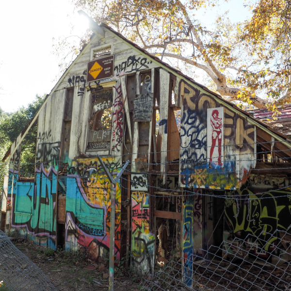
Murphy Ranch: What really happened at the rumored Nazi ranch?
Rumors abound about the ruins in Pacific Palisades. Here’s the true history.Hadley Meares (Curbed LA)
1,000 inmates have been working to stop #EatonFire & #PalisadesFire.
These inmates earn between $5.80 and $10.24 per day, additional $1 per hour from Cal Fire. They work a 24-hour shift = $30 per day.
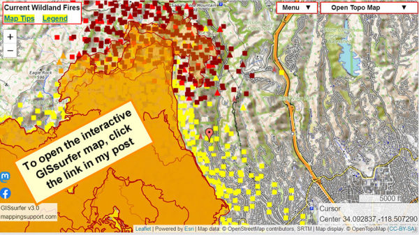
When the map opens there is a red marker (just below map center) at Cordelia Rd.
Fire is approaching this area. Helicopters dropping water are working. Structure defense teams are present. H/T @ai6yr for radio monitoring.
Open GISsurfer map:
https://mappingsupport.com/p2/gissurfer.php?center=34.092837,-118.507290&zoom=13&basemap=Open_Topo_Map&overlay=MODIS_7_day,VIIRS_7_day,Perimeter_FIRIS_intel,Fire_camera_location&data=https://mappingsupport.com/p2/special_maps/disaster/USA_wildland_fire.txt||34.084767,-118.507161
GISsurfer General Purpose Web Map and GIS Viewer | Surf GIS DATA
GISsurfer lets you surf a nearly endless amount of GIS data. Click a layer in the GIS server's table of contents and that data appears on the map.mappingsupport.com
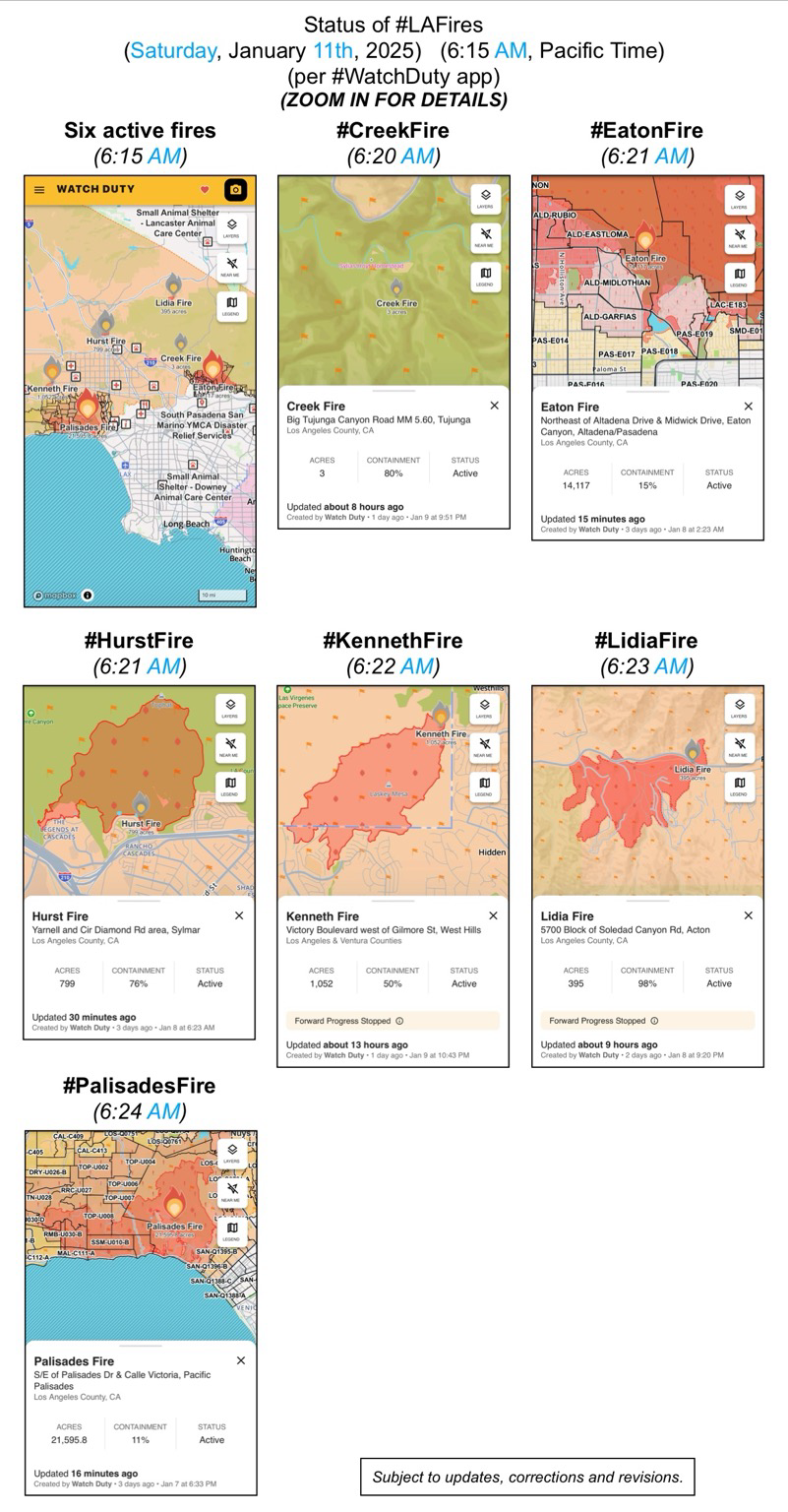
(Saturday, January 11th, 2025)
(6:15 AM, Pacific Time)
(per #WatchDuty app)
ZOOM IN FOR DETAILS
#CreekFire
#EatonFire
#HurstFire
#KennethFire
#LidiaFire
#PalisadesFire
(subject to updates, corrections, and revisions)
Watching Canadian fire bombers scoop water fr the ocean near my kid's apt has me sobbing. #gratitude https://www.tiktok.com/@dinameetsworld/video/7458080995569437998
Day 5: LA Fires Could Be California's Costliest Ever - EUROPE SAYS
Wildfires are burning across Los Angeles County.Hundreds of thousands of people are under evacuation orders or warnings.Insured lossesEUROPE SAYS (EUROPESAYS.COM)
The YMCA is providing no-cost child care for children of essential workers and families who have been displaced, evacuated, or experienced property loss due to the firestorms. Programs are available for children aged 4 years, 9 months through 8th grade and teens between 12 and up and are designed to assist families whose schools are currently closed.
#PalisadesFire #EatonFire #HurstFire #CreekFire #KennethFire #CAwx #LAUSD
SHELTER - Small Animal
Agoura Animal Care Center
29525 Agoura Rd, Agoura Hills, CA 91301, USA
Baldwin Park Animal Care Center
4275 Elton St, Baldwin Park
Carson Animal Care Center
216 W Victoria St, Gardena, CA
Downey Animal Care Center
11258 Garfield Ave, Downey CA
Lancaster Animal Care Center
5210 W Ave I, Lancaster. CA
Palmdale Animal Care Center
38550 Sierra Hwy, Palmdale. CA
@LASchools is here for our Palisades School Communities affected by the fires. Our Student Mental Health and Wellness Branch has activated Regional Crisis Response Teams to support schools in the Palisades community impacted by the wildfires. Together, we're committed to rebuilding and sustaining mental health and well-being. #WeAreLAUSD (1/3)
#PalisadesFire #EatonFire #HurstFire #CreekFire #KennethFire #CAwx #MentalHealth
FB posts bottom of the page from
Los Angeles County Department of Mental Health
“#LACountyresidents during these challenging times. Remember, our 24/7 Help Line is available for support at 1-800-854-7771. You can also download and use the iPrevail app to be connected to 24/7 on-demand support at lacounty.iprevail.com. Visit lacounty.gov/emergency for the latest updates”
#PalisadesFire #EatonFire #HurstFire #CreekFire #KennethFire #CAwx #MentalHealth
Department of Mental Health - hope. recovery. wellbeing.
hope. recovery. wellbeing.Department of Mental Health
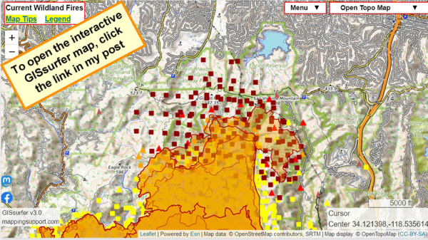
Latest perimeter shows 21,596 acres
Never ignore an order to evacuate. The fire officials have information that you do not.
Dark symbols on the map are MODIS and VIIRS satellite heat detections. This data is not real time and location are only approximate. Sometimes this data is ‘false positive’. For more information open the map and click “Map tips” upper left corner.
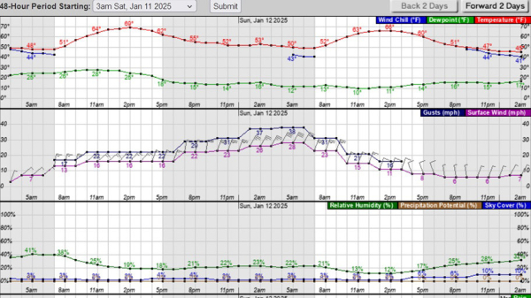
NOAA is forecasting wind gusts close to 40mph very early Sunday.
Open GISsurfer map:
https://mappingsupport.com/p2/gissurfer.php?center=34.121397,-118.535614&zoom=13&basemap=Open_Topo_Map&overlay=MODIS_7_day,VIIRS_7_day,Perimeter_FIRIS_intel,Fire_camera_location&data=https://mappingsupport.com/p2/special_maps/disaster/USA_wildland_fire.txt
GISsurfer General Purpose Web Map and GIS Viewer | Surf GIS DATA
GISsurfer lets you surf a nearly endless amount of GIS data. Click a layer in the GIS server's table of contents and that data appears on the map.mappingsupport.com
Palisades fire forces new evacuations in Brentwood - EUROPE SAYS
Los Angeles faces another tense night as the Palisades fire moved northeast, prompting new mandatory evacuations.The latest orderEUROPE SAYS (EUROPESAYS.COM)
What a shame. 🤦
#LosAngeles #WildFire #PalisadesFire #EatonFire #Fire #LA
https://ici.radio-canada.ca/nouvelle/2131793/feux-foret-avion-citerne-quebec-drone
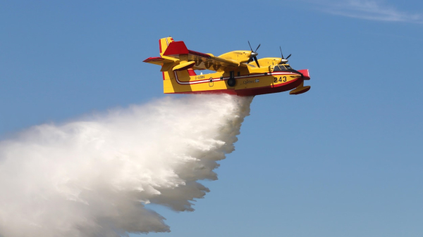
Un avion-citerne du Québec endommagé par un drone à Los Angeles
Un des deux avions-citernes CL-415 que le gouvernement du Québec a envoyés en Californie pour lutter contre les feux de broussailles a été cloué au sol jeudi après avoir heurté un drone civil au-dessus du brasier de Pacific Palisades, dans le comté d…Stéphane Bordeleau (Radio-Canada)
