Suche
Beiträge, die mit GIs getaggt sind


📍 26.–29. März in Münster
✨ Highlights:
🔹 Eröffnungssession „25 Jahre FOSSGIS“ mit Eszter Kiss
🔹 Fachvorträge zu #OpenData, Indoor-Positionsbestimmung & sicherer #OpenSource Entwicklung
Kommt vorbei & vernetzt euch mit uns! 🚀
https://fossgis-konferenz.de/2025/
#FOSSGIS2025 #OSM #GIS @FOSSGISeV @fossgis_konf

FOSSGIS 2025
Die FOSSGIS-Konferenz ist im D-A-CH Raum die führende Konferenz für Freie und Open Source Software für Geoinformationssysteme OpenStreetMap.fossgis-konferenz.de
https://en.wikipedia.org/wiki/Ben_Gurion_International_Airport
https://www.openstreetmap.org/#map=13/32.011398/34.886700
#LLBG #TLV #TelAviv #Israel #airport #aviation #avgeeks #GIS
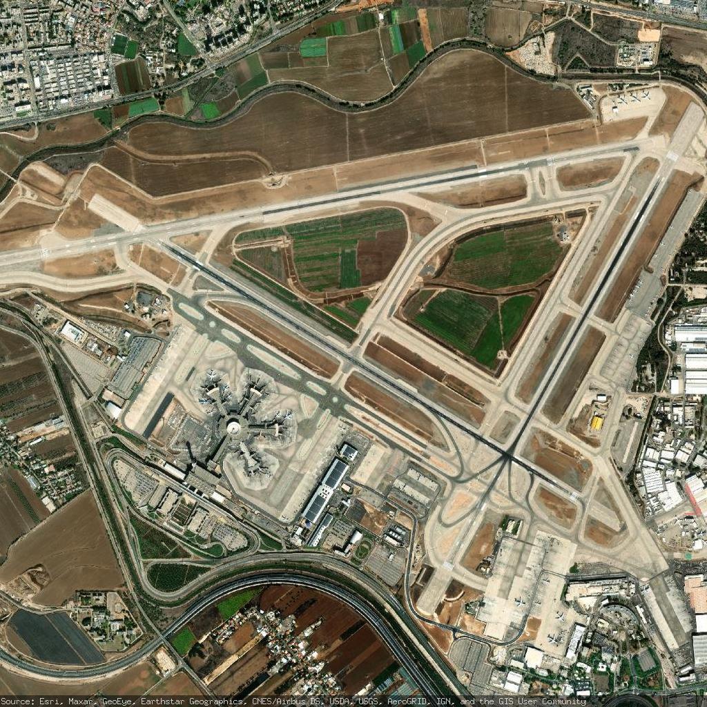
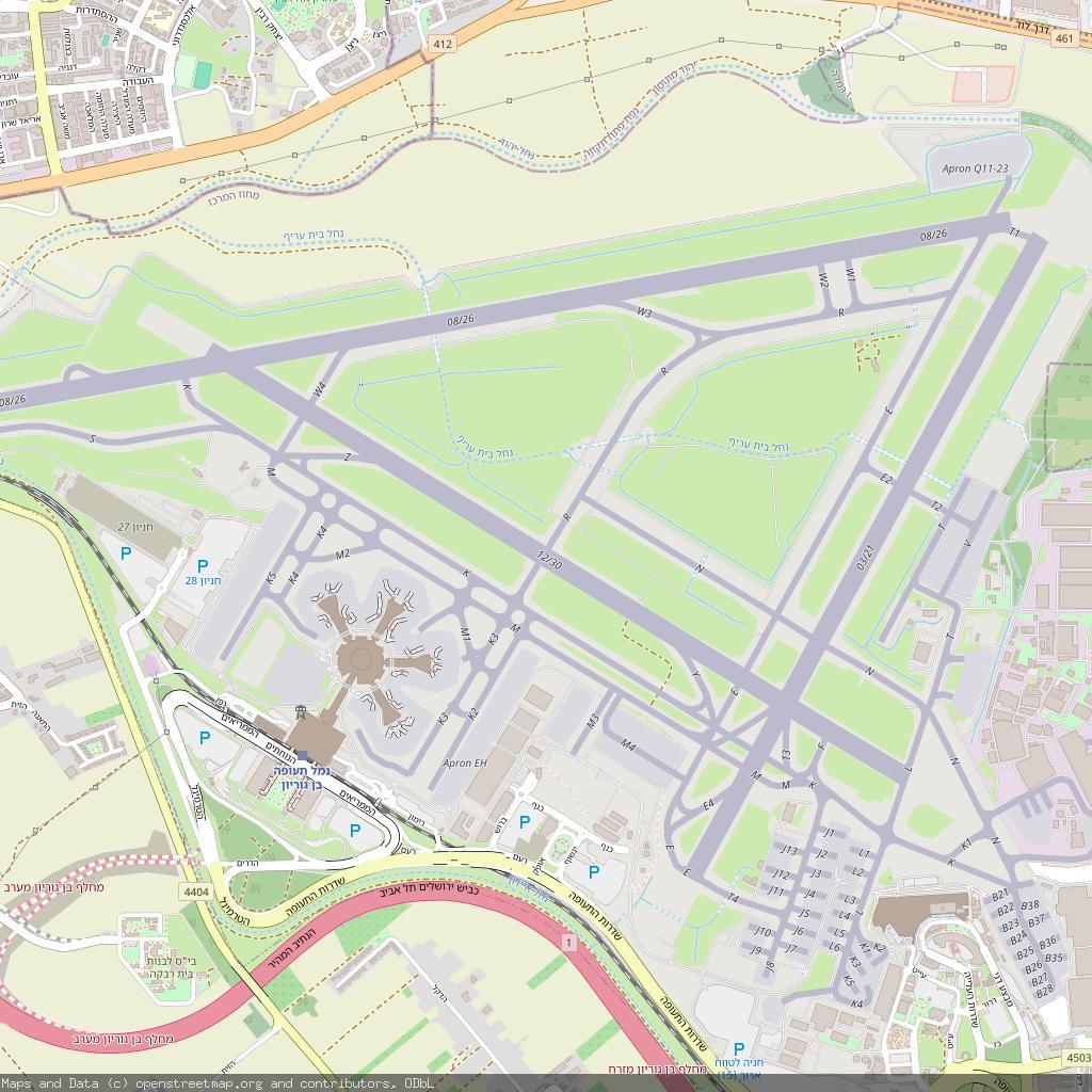
OpenStreetMap
OpenStreetMap is a map of the world, created by people like you and free to use under an open license.OpenStreetMap
So I found that #DOGE is currently in the org I work at. Ive confirmed from 2 colleagues. They're going after contractors first, since we have mostly no protections.
I've been looking since Nov 6, but now things are getting down to the wire.
I'm a senior cloud systems engineer. Current is administering/developing #ArcGIS #GIS . Previously was systems engineer with greenfielding and putting together multiple ATO's. Before that, was systems engineer at a NOC.
I highly prefer #remote but can travel 60 miles around #bloomingtonIN
Mit einem befreundeten Künstler habe ich eine experimentelle #Soundinstallation gemacht. Falls es euch interessiert, wie aus #Geodaten #Musik bzw #Sound generiert wird, sagt gern bescheid oder schaut euch die Ausstellung an. Einladungstext in den Kommentaren
#gis #gischat #midi #synthesizer #ableton #karten #weirdmaps #Kunst #art #Spatial #geography #geospatial #mapping #mapstodon


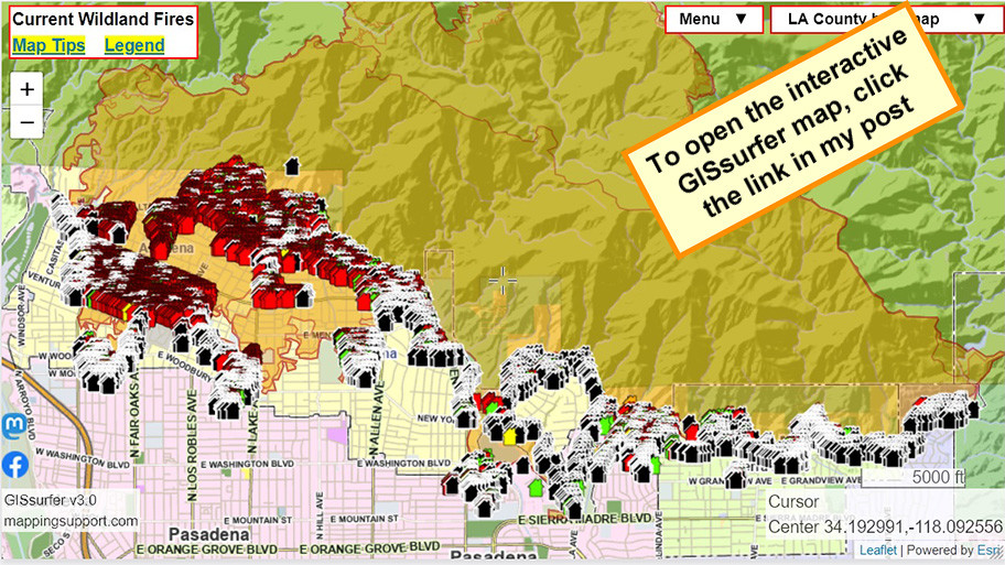
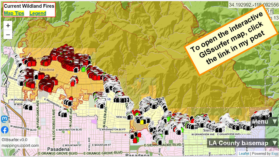
To search on an address click Menu > Search.
Red - Destroyed > 50%
Orange - Major 26-50%
Yellow - Minor 10-25%
Green - Affected 1-9%
Black - No damage
White - Inaccessible
Open GISsurfer map:
https://mappingsupport.com/p2/gissurfer.php?center=34.192992,-118.092556&zoom=13&basemap=LA_County_basemap&overlay=Perimeter_FIRIS_intel,LA_County_map,LA_County_parcels,Eaton_damage_assessment&data=https://mappingsupport.com/p2/special_maps/disaster/USA_wildland_fire.txt

GISsurfer General Purpose Web Map and GIS Viewer | Surf GIS DATA
GISsurfer lets you surf a nearly endless amount of GIS data. Click a layer in the GIS server's table of contents and that data appears on the map.mappingsupport.com
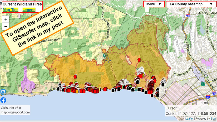
To search on an address click Menu > Search.
Red - Destroyed > 50%
Orange - Major 26-50%
Yellow - Minor 10-25%
Green - Affected 1-9%
Black - No damage
White - Inaccessible
Open GISsurfer map:
https://mappingsupport.com/p2/gissurfer.php?center=34.074127,-118.591234&zoom=12&basemap=LA_County_basemap&overlay=Perimeter_FIRIS_intel,LA_County_map,LA_County_parcels,Palisades_damage_assessment&data=https://mappingsupport.com/p2/special_maps/disaster/USA_wildland_fire.txt

GISsurfer General Purpose Web Map and GIS Viewer | Surf GIS DATA
GISsurfer lets you surf a nearly endless amount of GIS data. Click a layer in the GIS server's table of contents and that data appears on the map.mappingsupport.com
To search on an address click Menu > Search.
Red - Destroyed > 50%
Orange - Major 26-50%
Yellow - Minor 10-25%
Green - Affected 1-9%
Black - No damage
White - Inaccessible
Open GISsurfer map:
https://mappingsupport.com/p2/gissurfer.php?center=34.192992,-118.092556&zoom=13&basemap=LA_County_basemap&overlay=Perimeter_FIRIS_intel,LA_County_map,LA_County_parcels,Eaton_damage_assessment&data=https://mappingsupport.com/p2/special_maps/disaster/USA_wildland_fire.txt

GISsurfer General Purpose Web Map and GIS Viewer | Surf GIS DATA
GISsurfer lets you surf a nearly endless amount of GIS data. Click a layer in the GIS server's table of contents and that data appears on the map.mappingsupport.com
To search on an address click Menu > Search.
Red - Destroyed > 50%
Orange - Major 26-50%
Yellow - Minor 10-25%
Green - Affected 1-9%
Black - No damage
White - Inaccessible
Open GISsurfer map:
https://mappingsupport.com/p2/gissurfer.php?center=34.074127,-118.591234&zoom=12&basemap=LA_County_basemap&overlay=Perimeter_FIRIS_intel,LA_County_map,LA_County_parcels,Palisades_damage_assessment&data=https://mappingsupport.com/p2/special_maps/disaster/USA_wildland_fire.txt

GISsurfer General Purpose Web Map and GIS Viewer | Surf GIS DATA
GISsurfer lets you surf a nearly endless amount of GIS data. Click a layer in the GIS server's table of contents and that data appears on the map.mappingsupport.com
To search on an address click Menu > Search.
Red - Destroyed > 50%
Orange - Major 26-50%
Yellow - Minor 10-25%
Green - Affected 1-9%
Black - No damage
White - Inaccessible
Open GISsurfer map:
https://mappingsupport.com/p2/gissurfer.php?center=34.192992,-118.092556&zoom=13&basemap=LA_County_basemap&overlay=Perimeter_FIRIS_intel,LA_County_map,LA_County_parcels,Eaton_damage_assessment&data=https://mappingsupport.com/p2/special_maps/disaster/USA_wildland_fire.txt
GISsurfer General Purpose Web Map and GIS Viewer | Surf GIS DATA
GISsurfer lets you surf a nearly endless amount of GIS data. Click a layer in the GIS server's table of contents and that data appears on the map.mappingsupport.com
To search on an address click Menu > Search.
Red - Destroyed > 50%
Orange - Major 26-50%
Yellow - Minor 10-25%
Green - Affected 1-9%
Black - No damage
White - Inaccessible
Open GISsurfer map:
https://mappingsupport.com/p2/gissurfer.php?center=34.074127,-118.591234&zoom=12&basemap=LA_County_basemap&overlay=Perimeter_FIRIS_intel,LA_County_map,LA_County_parcels,Palisades_damage_assessment&data=https://mappingsupport.com/p2/special_maps/disaster/USA_wildland_fire.txt

GISsurfer General Purpose Web Map and GIS Viewer | Surf GIS DATA
GISsurfer lets you surf a nearly endless amount of GIS data. Click a layer in the GIS server's table of contents and that data appears on the map.mappingsupport.com
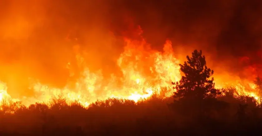
#wildfires #EmergencyResponse #CAFires #LAFires #publicsafety #govtech #esri #arcgis #mapping #GISchat #geospatial #mapstodon @esri @gispublicsafety @esrislgov @urisa
To search on an address click Menu > Search.
Red - Destroyed > 50%
Orange - Major 26-50%
Yellow - Minor 10-25%
Green - Affected 1-9%
Black - No damage
White - Inaccessible
Open GISsurfer map:
https://mappingsupport.com/p2/gissurfer.php?center=34.192992,-118.092556&zoom=13&basemap=LA_County_basemap&overlay=Perimeter_FIRIS_intel,LA_County_map,LA_County_parcels,Eaton_damage_assessment&data=https://mappingsupport.com/p2/special_maps/disaster/USA_wildland_fire.txt
GISsurfer General Purpose Web Map and GIS Viewer | Surf GIS DATA
GISsurfer lets you surf a nearly endless amount of GIS data. Click a layer in the GIS server's table of contents and that data appears on the map.mappingsupport.com
To search on an address click Menu > Search.
Red - Destroyed > 50%
Orange - Major 26-50%
Yellow - Minor 10-25%
Green - Affected 1-9%
Black - No damage
White - Inaccessible
Open GISsurfer map:
https://mappingsupport.com/p2/gissurfer.php?center=34.074127,-118.591234&zoom=12&basemap=LA_County_basemap&overlay=Perimeter_FIRIS_intel,LA_County_map,LA_County_parcels,Palisades_damage_assessment&data=https://mappingsupport.com/p2/special_maps/disaster/USA_wildland_fire.txt
GISsurfer General Purpose Web Map and GIS Viewer | Surf GIS DATA
GISsurfer lets you surf a nearly endless amount of GIS data. Click a layer in the GIS server's table of contents and that data appears on the map.mappingsupport.com
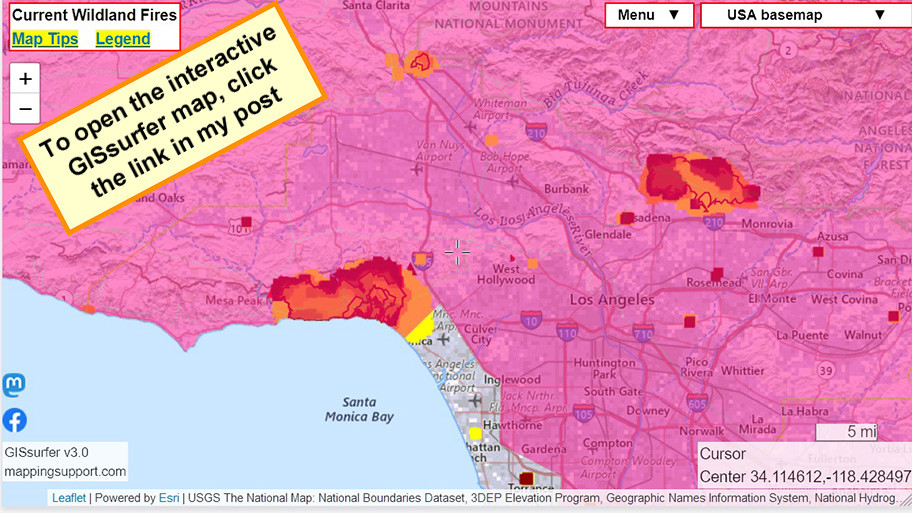
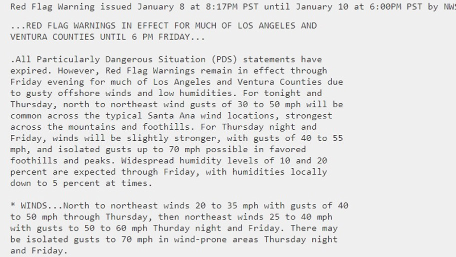
#WindAdvisory
#HighWindWatch
To read details from NOAA, open the map, click colored area, follow the link. Scroll down in the popup since each type of watch or warning has its own link for the details.
Latest perimeter for the #PalisadesFire shows 17,234 acres burned. Zoom in for details.
The maps has lots of #GIS layers that you can turn on/off/restack.
You can make your own custom map links that show the data you want to see.
You can change the ‘top’ layer that is clickable to see attribute data.
Need help? Open the map and see 2 links upper left corner.
#EatonFire #SunsetFire #Geospatial #GISchat
Open GISsurfer map:
https://mappingsupport.com/p2/gissurfer.php?center=34.114612,-118.428497&zoom=10&basemap=USA_basemap&overlay=MODIS_7_day,VIIRS_7_day,Lake_river_stream,Perimeter_FIRIS_intel,Red_flag_warning&data=https://mappingsupport.com/p2/special_maps/disaster/USA_wildland_fire.txt

GISsurfer General Purpose Web Map and GIS Viewer | Surf GIS DATA
GISsurfer lets you surf a nearly endless amount of GIS data. Click a layer in the GIS server's table of contents and that data appears on the map.mappingsupport.com

Future unclear for King Island Dairy as Saputo puts island's only milk processor up for sale
The potential sell-off of the only dairy processing plant on King Island comes as a little surprise to locals who have witnessed a dwindling industry.Meg Powell (ABC News)