Suche
Beiträge, die mit PalisadesFIre getaggt sind
You'll note, despite the TV drama/etc., there is no active fire in these photos (except some smoke off Eaton on the northern side). There is mop up ongoing on the fire, etc.
The number of structures damaged, however, is staggering.
https://storms.ngs.noaa.gov/storms/2025_eri/index.html#11.93/34.05434/-118.4974
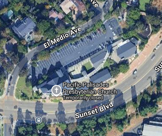
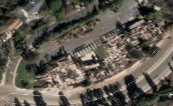
Pacific Palisades Prebysterian Church (Before/After) on Sunset Blvd. (After: MAXAR remote imaging).
#PalisadesFire #RemoteImaging #MAXAR
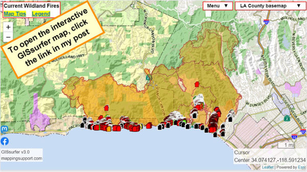
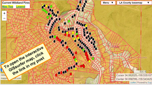
These are the map’s color codes: black for no damage, green for 1–9% affected, yellow for 10–25% affected, orange for 26–50% affected, and red for more than 50% destroyed.
#palisadesFire #eatonFire #altadena
https://recovery.lacounty.gov/eaton-fire/
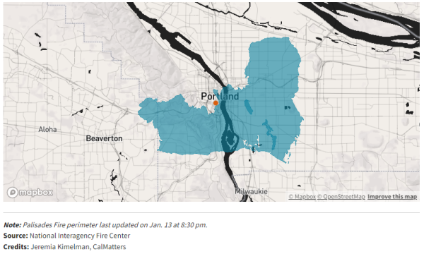
https://calmatters.org/environment/wildfires/2025/01/la-fires-size-mapped/
Thanks to @jeremiak for this tool. I used the address of City Hall.
#Portland #PalisadesFire
LA fires: How would a blaze this size impact where you live? - CalMatters
To better understand the size of the LA fires, our tool lets you overlay the fire perimeters on any location in California.John Osborn D'Agostino (CalMatters)
Los Angeles County Disaster Recovery Centers Are Open for Hurricane-Force Firestorm Survivors
Published: Jan 13, 2025
California Governor’s Office of Emergency Services (Cal OES), Federal Emergency Management Agency (FEMA) and the County of Los Angeles along with other state and local partners, are opening two Disaster Recovery Centers (DRC) in Los Angeles County on Tuesday, January 14th at 1:00pm.
#wildfires #CAwx #LosAngeles #EatonFire #PalisadesFire https://news.caloes.ca.gov/los-angeles-county-disaster-recovery-centers-open-tuesday-for-hurricane-force-firestorm-survivors/
"Vital records: If you have been directly impacted by the fires, you can request property and vital records (i.e., birth, death, marriage) free of charge by calling 800-201-8999 or emailing recorder@rrcc.lacounty.gov "
https://thirdact.org/blog/we-love-l-a/
Pacific Surfliner is offering $10 fares for travel anywhere on the LOSSAN Rail Corridor (San Diego to San Luis Obispo) to assist those impacted by the Southern #California #wildfires.
https://www.pacificsurfliner.com/offers/promotions/Assist/
Explore the SoCal Coast by Train | Pacific Surfliner
Book a ticket online and travel by train along the Southern California coast to destinations like San Diego, Orange County, Los Angeles, and San Luis Obispo.Pacific Surfliner
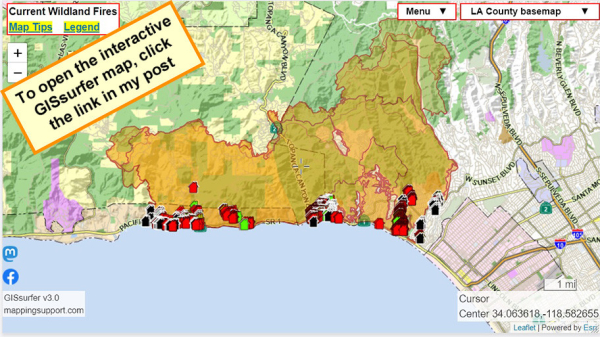
To search on an address click Menu > Search.
Red - Destroyed > 50%
Orange - Major 26-50%
Yellow - Minor 10-25%
Green - Affected 1-9%
Black - No damage
White - Inaccessible
Open GISsurfer map:
https://mappingsupport.com/p2/gissurfer.php?center=34.074127,-118.591234&zoom=12&basemap=LA_County_basemap&overlay=Perimeter_FIRIS_intel,LA_County_map,LA_County_parcels,Palisades_damage_assessment&data=https://mappingsupport.com/p2/special_maps/disaster/USA_wildland_fire.txt
GISsurfer General Purpose Web Map and GIS Viewer | Surf GIS DATA
GISsurfer lets you surf a nearly endless amount of GIS data. Click a layer in the GIS server's table of contents and that data appears on the map.mappingsupport.com
https://recovery.lacounty.gov/
#EatonFire #PalisadesFire #LACounty #wildfires
Santa Paula, Ventura County - Former shelter dogs on the front lines of Los Angeles wildfire search efforts
https://ktla.com/news/california/wildfires/former-shelter-dogs-on-the-front-lines-of-los-angeles-wildfire-search-efforts/
Send them to jail.
#PalisadesFire
https://popular.info/p/landlords-gouge-victims-of-la-fires
@juddlegum

Landlords gouge victims of LA fires
The devastating fires in Los Angeles have killed 24 people.Judd Legum (Popular Information)
#NationalGuard plane combats #Californiafire
A National Guard #plane dropped #fireretardant on the #PalisadesFire.
https://www.usatoday.com/videos/news/2025/01/13/inside-cockpit-national-guard-plane-combats-palisades-fire/77665843007/?for-guid=7630a6c9-de51-4bad-8bf0-674b31659194
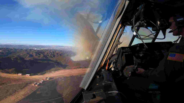
Inside the cockpit: National Guard plane combats Palisades Fire
A National Guard plane dropped fire retardant on the Palisades Fire.www.usatoday.com
Beyoncé Delays Jan. 14th Announcement Due to Los Angeles Fires
Beyoncé Delays Jan. 14th Announcement Due to Los Angeles Fires - INBELLAINBELLA
https://youtu.be/-hNqxFyY6BY
#MeghanMarkle #PrinceHarry #LosAngeles #LosAngelesWildfires #PalisadesFire #wildfires #Wildfires2025 #CaliforniaWildfires
Jimmy Kimmel Breaks Up Over L.A. Wildfires, Takes Aim at Trump
Jimmy Kimmel Breaks Up Over L.A. Wildfires, Takes Aim at Trump - INBELLAINBELLA
#FckMusk #uspol #PalisadesFire
- YouTube
Auf YouTube findest du die angesagtesten Videos und Tracks. Außerdem kannst du eigene Inhalte hochladen und mit Freunden oder gleich der ganzen Welt teilen.www.youtube.com
Jennifer Meyer Discusses Los Angeles Wildfires Impact on the Westside
Jennifer Meyer Discusses Los Angeles Wildfires Impact on the Westside - INBELLAINBELLA
#PalisadesFire https://share.watchduty.org/i/40335?ts=1736823752000
#EatonFire https://share.watchduty.org/i/40388?ts=1736824668000
#AutoFire https://share.watchduty.org/i/40675?ts=1736826823000
@ai6yr will also be watching the Auto Fire.
Watch Duty - Wildfire Maps & Alerts
Real-time information about wildfire and firefighting efforts nearbyWatch Duty
Visit lapl.org/branches for hours and updates. Emergency information and resources can be found at lapl.org/be-ready. #N95 #PalisadesFire
https://oag.ca.gov/contact/consumer-complaint-against-business-or-company
https://laist.com/news/housing-homelessness/los-angeles-palisades-fire-housing-rent-price-gouging-law-california-zillow-listing
#eatonFire #PalisadesFire #Housing #PriceGouging

Asking rents skyrocket as LA fires destroy homes
For one listing, rent jumped nearly 86% since September. In an interview with LAist, the agent said she told her client, “People are desperate, and you can probably get good money.”David Wagner (LAist)
FBI seen at Ben Affleck’s LA home as they conduct activity surrounding Palisades Fire
FBI seen at Ben Affleck's LA home as they conduct activity surrounding Palisades Fire - INBELLAINBELLA
https://www.theglobeandmail.com/canada/article-canadian-firefighters-head-to-help-fight-california-wildfires-as/
#palisadesfire #cdnpoli #lafires
Canadian firefighters to help fight California wildfires as Ottawa, premiers pledge resources
The united show of support, in which Canada is sending 250 firefighters, waterbombers and other equipment, is seen as highlighting strength of U.S.-Canada relations strained by threats of tariffs and annexationAndrea Woo (The Globe and Mail)
#FireResources
#PalisadesFire
this just in:
https://mailchi.mp/listoscalifornia/listos-california-special-edition-socal-wildfire-preparedness-resources-5836664?e=a8f5d16808
temporary flight restriction (TFR) collided with a firefighting aircraft. ... The FBI has set up a Digital Media Tipline, and is seeking the public’s help in order to identify the operator of the drone. Anyone with information, photos, and/or
video footage of the incident is asked to submit them to http://www.fbi.gov/palisadesdronestrike.
#Drone #PalisadesFire #FBI #tips
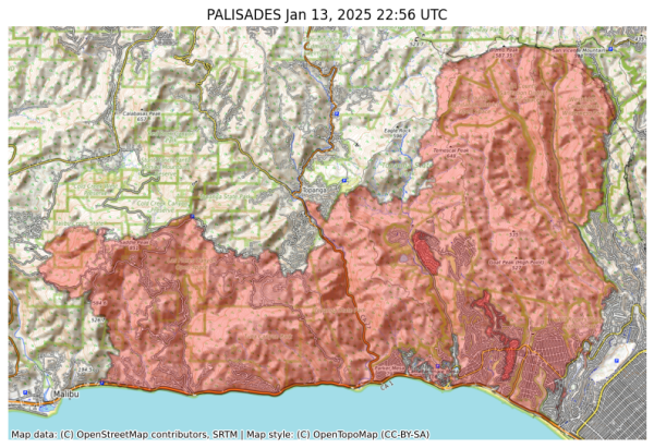
NIFC New Or Updated Wildfire Perimeter
Incident Name: PALISADES
Acres: 23461.4 acres
Updated: Jan 13, 2025 22:56 UTC
Source: IRWIN
#PALISADESFire #CAwx
To search on an address click Menu > Search.
Red - Destroyed > 50%
Orange - Major 26-50%
Yellow - Minor 10-25%
Green - Affected 1-9%
Black - No damage
White - Inaccessible
Open GISsurfer map:
https://mappingsupport.com/p2/gissurfer.php?center=34.058354,-118.543639&zoom=16&basemap=LA_County_basemap&overlay=Perimeter_FIRIS_intel,LA_County_map,LA_County_parcels,Palisades_damage_assessment&data=https://mappingsupport.com/p2/special_maps/disaster/USA_wildland_fire.txt
GISsurfer General Purpose Web Map and GIS Viewer | Surf GIS DATA
GISsurfer lets you surf a nearly endless amount of GIS data. Click a layer in the GIS server's table of contents and that data appears on the map.mappingsupport.com
To search on an address click Menu > Search.
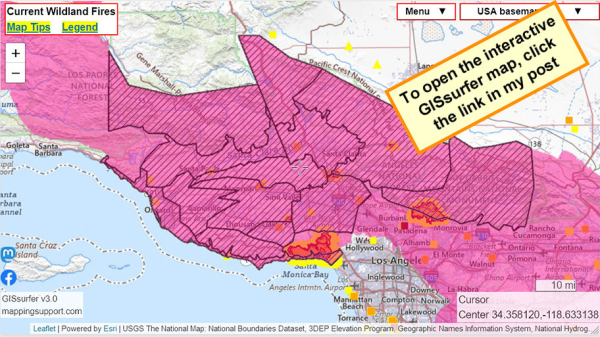
For official details from NOAA including timing, open the map, zoom in, click in red area. Scroll down in the popup that appears since there might be multiple weather watches/warnings for the spot you clicked and each one has its own link to the details.
#PalisadesFire #EatonFire #LAfires #SantaAnna
Open GISsurfer map:
https://mappingsupport.com/p2/gissurfer.php?center=34.358120,-118.633138&zoom=9&basemap=USA_basemap&overlay=MODIS_7_day,VIIRS_7_day,Perimeter_FIRIS_intel,High_wind_warning,Red_flag_warning&data=https://mappingsupport.com/p2/special_maps/disaster/USA_wildland_fire.txt
GISsurfer General Purpose Web Map and GIS Viewer | Surf GIS DATA
GISsurfer lets you surf a nearly endless amount of GIS data. Click a layer in the GIS server's table of contents and that data appears on the map.mappingsupport.com
I have to limit my viewing time, lol.
https://calfire-forestry.maps.arcgis.com/home/webscene/viewer.html?webscene=0a7381c8b46b4e26a057383424f32c06
#fires #LosAngeles #PalisadesFire #EatonFire #3D
https://www.coloradoboulevard.net/use-of-leaf-blower-is-prohibited-in-l-a-county-until-further-notice/
#wildfires #firewx #EatonFire #PalisadesFire #landscaping
A Lahaina Fire Survivor’s Step-by-Step Guide to Recovering From Tragedy and What to Do First
A former Billboard editor-in-chief (and THR music editor) and her family escaped the inferno that reduced her beloved Maui town to ashes. She offers actionable steps for those in the same position following the blazes raging across Los Angeles.
https://www.hollywoodreporter.com/news/local-news/lahaina-fire-survivor-guide-recovering-tragedy-what-to-do-1236107722/
#wildfires #EatonFire #PalisadesFire #LahainaFire #firewx #disasters
Shelters Available for Communities Impacted by Wildfires in Southern California
Published: Jan 13, 2025
As California endures wildfires fueled by high winds, the California Governor’s Office of Emergency Services (Cal OES) is coordinating with the California Department of Social Services and local governments to ensure impacted communities have access to shelters and vital services.
For specific shelter operation details, please contact your local authorities.
(see list below)
https://news.caloes.ca.gov/shelters-available-for-communities-impacted-by-wildfires-in-southern-california-5/
#wildfires #firewx #EatonFire #PalisadesFire
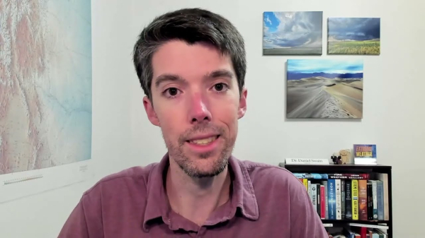
Weather and climate office hours: 01/13/2025 topic: Coverage of SoCal wildfires & new wind event
The latest in a recurring series of live, virtual, & interactive "office hours" hosted by Dr. Daniel Swain on various topics related to extreme weather and c...YouTube
Democrats are discussing how to recover.
Republicans are blaming Democrats, but offer no policies.
Where are those people going to live?
Once they rebuild, how will their homes be insured?
How will the communities survive?
Meanwhile, Trump offers multiple distractions: Mexico, Canada, Greenland, Panama, spending cuts (MediCare, Medicaid, SNAP, school lunches, …).
#palisadesfire
$83M Mansion From 'Succession' Burns Down in LA Wildfires: Report - EUROPE SAYS
A luxury Pacific Palisades mansion once featured in 'Succession' has been destroyed by the LA fires, the DailyEUROPE SAYS (EUROPESAYS.COM)
Kinneloa Irrigation District
LADWP for Zip Code 90272
LACWD No 21, Kagel Canyon
LACWD No 29, Malibu
Las Flores Water Company
Lincoln Water Company
Pasadena Water and Power
Rubio Canon Land and Water Association
https://waterforla.lacounty.gov/water-alerts/
#wildfires #LAFires #EatonFire #PalisadesFire #HurstFire
Water Alerts - Water for LA County
Water Alerts for the Palisades Fire, Eaton Fire, Hurst Fire, Kenneth Fire and other wildfires.Water for LA County
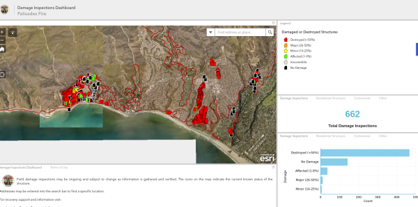
To search on an address click Menu > Search.
The damage layer is 'on top' and clickable.
The parcel layer (at end of overlay list) includes address and owner's name. To learn how to make that the 'top' layer and clickable, please read the "Map tips" link in upper left corner.
Red - Destroyed > 50%
Orange - Major 26-50%
Yellow - Minor 10-25%
Green - Affected 1-9%
Black - No damage
White - Inaccessible
Open GISsurfer map:
https://mappingsupport.com/p2/gissurfer.php?center=34.063618,-118.582655&zoom=12&basemap=LA_County_basemap&overlay=Perimeter_FIRIS_intel,LA_County_map,LA_County_parcels,Palisades_damage_assessment&data=https://mappingsupport.com/p2/special_maps/disaster/USA_wildland_fire.txt
GISsurfer General Purpose Web Map and GIS Viewer | Surf GIS DATA
GISsurfer lets you surf a nearly endless amount of GIS data. Click a layer in the GIS server's table of contents and that data appears on the map.mappingsupport.com
(Note they have done 662 inspections, likely there are more than 5000 structures destroyed here in the Palisades Fire. This map also includes damage from the earlier Franklin Fire)
#PalisadesFire #PacificPalisades #Malibu #FranklinFire

