Suche
Beiträge, die mit Map getaggt sind

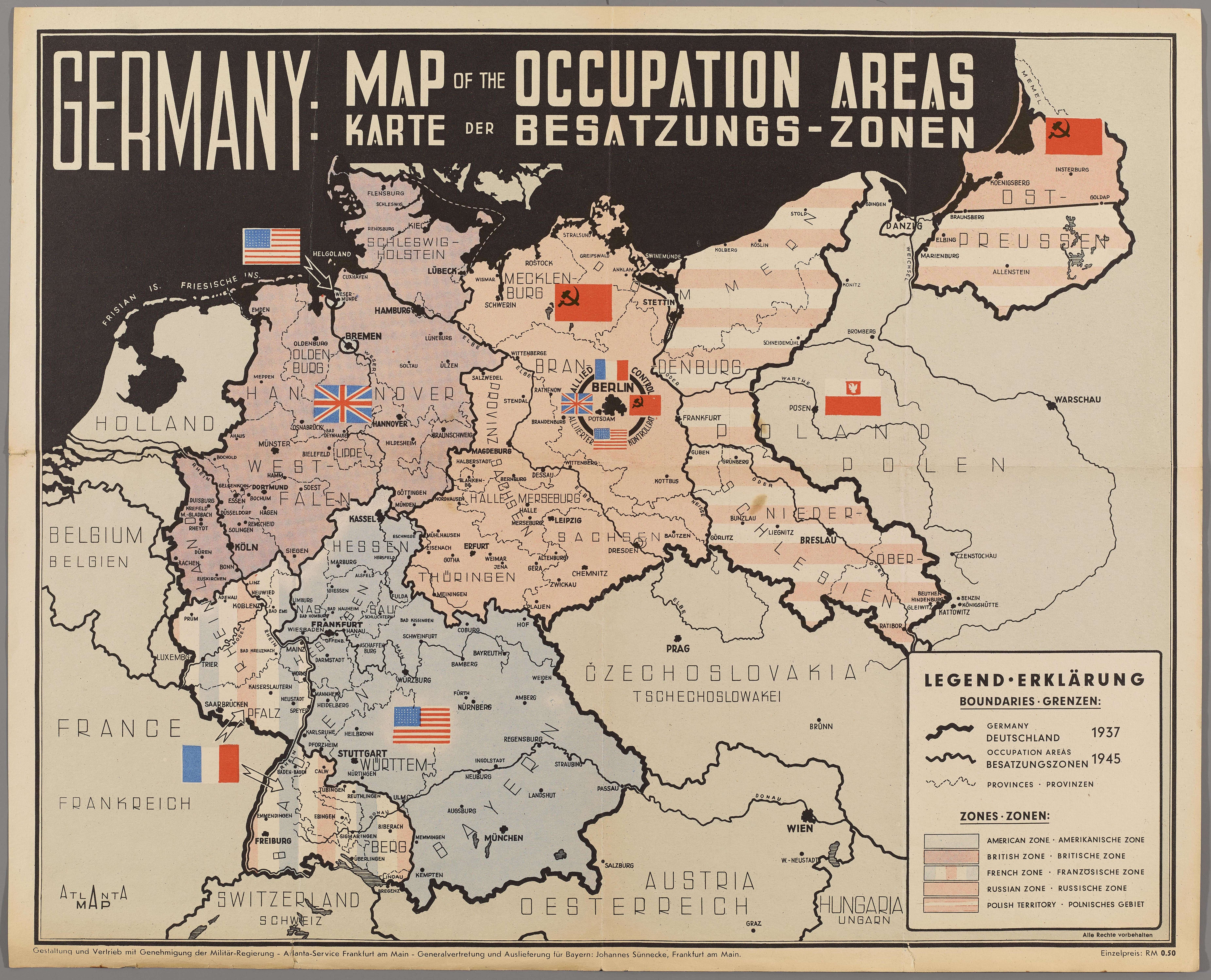
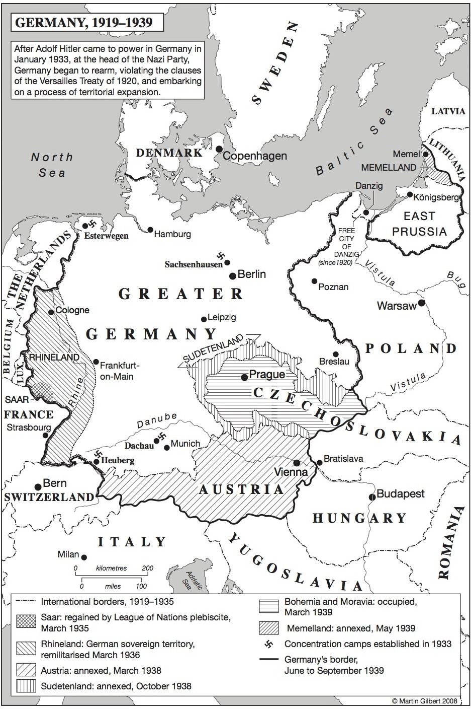
#1945 #WWII #WW2 #map #history #Saxony #Franconia #Prussia #Deutschland #Germany #Franken #AngloSaxons #Prussians #Allemagne #histoire #europe
American map of the occupation areas in Post-War Germany #1945 #198...
American map of the occupation areas in Post-War Germany #1945 #1989 #WW2 #Map #Atlas #History #Saxony #Franconia #Prussia #Deutschland #Germany #Franken #AngloSaxons #Prussians #Allemagne #Histoire #Europe Entrer une description pour l'image ici htt…diaspora* social network
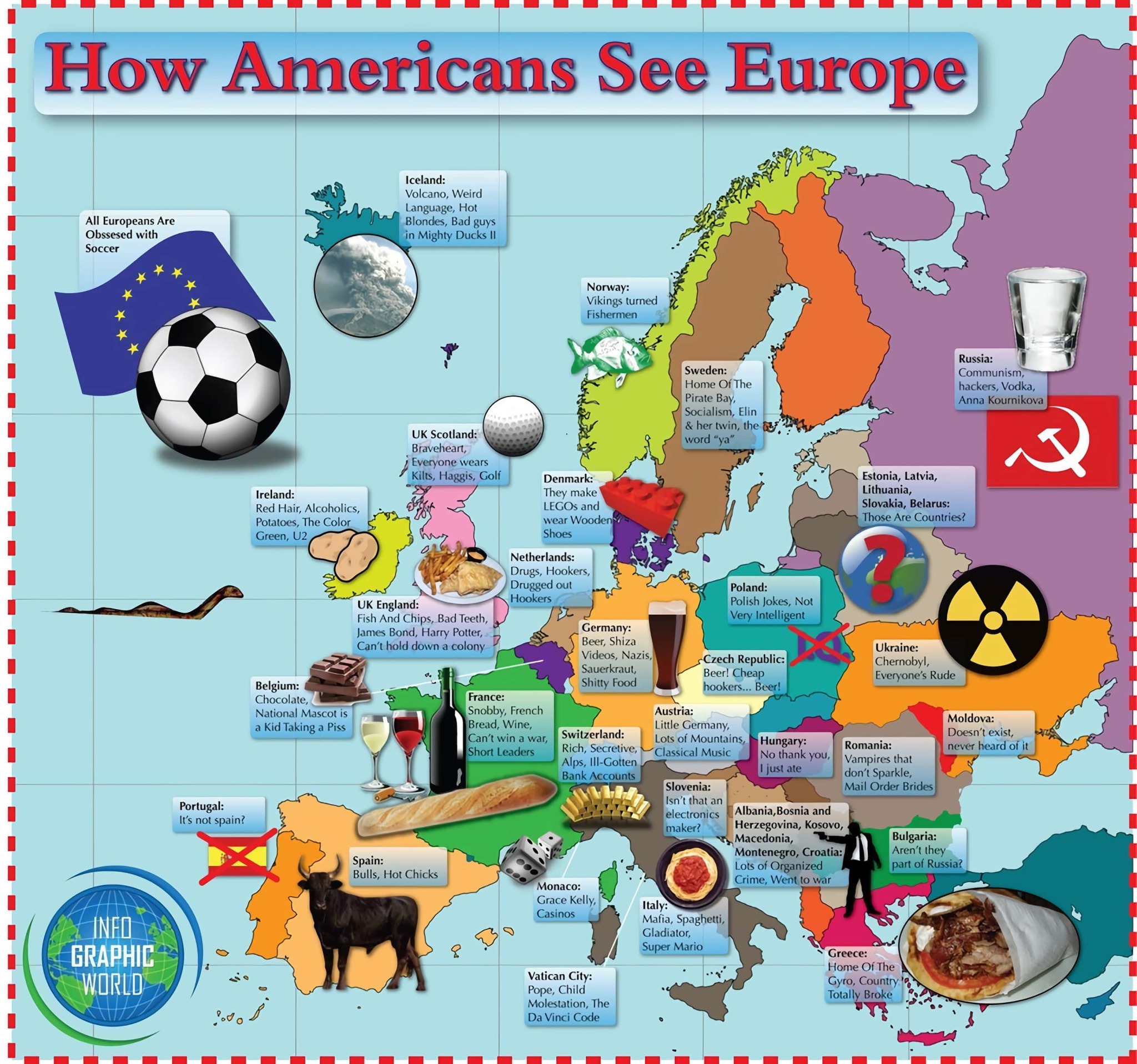
#american #stereotypes #map of #europe

How Americans View Europe.
https://mapsontheweb.zoom-maps.com/post/111183292594/how-europeans-think-americans-view-europe-more

OnlMaps (@onlmaps@mastodon.social)
8.27K Posts, 23 Following, 3.12K Followers · Cartography, maps, mapmakers, news on maps, route planners, historical maps from around the world.Mastodon
#thetruesize #map #country #size #projektion #karte #welt #world

Compare Countries With This Simple Tool
Drag and drop countries around the map to compare their relative size. Is Greenland really as big as all of Africa? You may be surprised at what you find! A great tool for educators.The True Size
#map #oepnstreet #openstreetmap #karte #gpogle #googlemaps
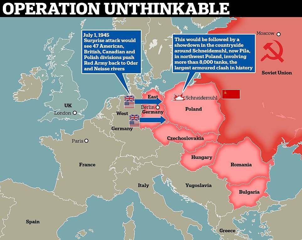
Operation Unthinkable
#Russia #USSR #soviet #russian #history #map #WWII #WW2 #europe #USA #US #american #UK #britain #england #british #canadian #polish #Western #war #warmongers #СССР #история
In 1945, Winston Churchill considered starting a war with the Soviet Union right after WW2
https://mapsontheweb.zoom-maps.com/post/677255974923419649/in-1945-winston-churchill-considered-starting-aMaps on the Web
In 1945, Winston Churchill considered starting a war with the Soviet Union right after World War 2. Operation Unthinkable was the name given to two related possible future war plans developed by the...mapsontheweb (Tumblr)


OnlMaps (@onlmaps@mastodon.social)
8.27K Posts, 23 Following, 3.12K Followers · Cartography, maps, mapmakers, news on maps, route planners, historical maps from around the world.Mastodon


Information Is Beautiful (@infobeautiful@vis.social)
392 Posts, 86 Following, 6.78K Followers · Data visualizations & information graphics by David McCandless. Plus favourite finds from around the web. Making sense of the world - well, trying to - since 2009.vis.social
… einem möglichst vollwertigen Ersatz für Garmins Basecamp.
Nachdem ich mittlerweile mit der Einkaufsliste / Bestandsverwaltung #Grocy (https://mstdn.mv2k.com/deck/@memo/113922072350218372) sehr zufrieden bin, ist die letzte #Software, die mich noch an #Windows bindet - #Basecamp (https://www.garmin.com/de-DE/software/basecamp/).
Sollte ich einen passenden Ersatz für #Linux finden, kann ich mich komplett von #Microsoft verabschieden 😀
Die Alternative sollte #GPX Dateien importieren und im Anschluss editieren ‼️ können, sowie möglichst #OpenStreeMap als #Kartenmaterial verwenden. Das Einbinden anderer Karten wie zum Beispiel der #OFM (OpenFietsMap https://www.openfietsmap.nl/) wäre ein nicht zu verachtender Bonuspunkt.
Zurzeit nutze ich die “Organic Maps Betaversion” (https://organicmaps.app/de/) und zum Bearbeiten den “Viking GPS data editor” (https://sourceforge.net/p/viking/wikiallura/Main_Page/).
Das funktioniert (irgendwie) ist aber für den ständigen, oder schnellen Gebrauch nicht die Ideallösung ¯\_(ツ)_/¯
#Garmin #Map #OpenSource #rad #bike #fahrrad #radtour

Organic Maps: Offline Wandern, Radfahren, Wanderwege und Navigation
Schnelle, detaillierte Offline-Karten für Reisende, Touristen, Autofahrer, Wanderer und Radfahrer, erstellt von den Gründern der MapsWithMe-App (Maps.Me).organicmaps.app
#solidarityeconomy
Free research server: https://shareish.org
Communities & Technologies 2023 Paper: https://doi.org/10.1145/3593743.359379


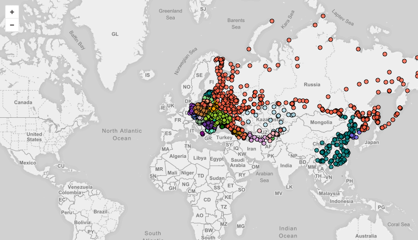
African tribes that were the most taken to The Americas during The Trans Atlantic Slave Trade
African tribes that were the most taken to The Americas during The Trans Atlantic Slave TradePosted by NickiMinajcousinBYTESEU (Bytes Europe)
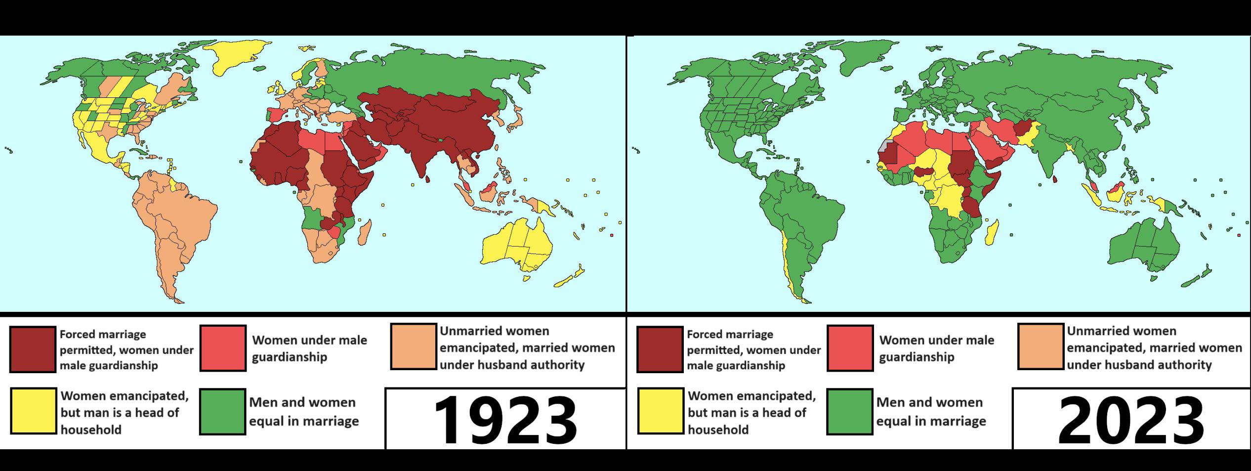
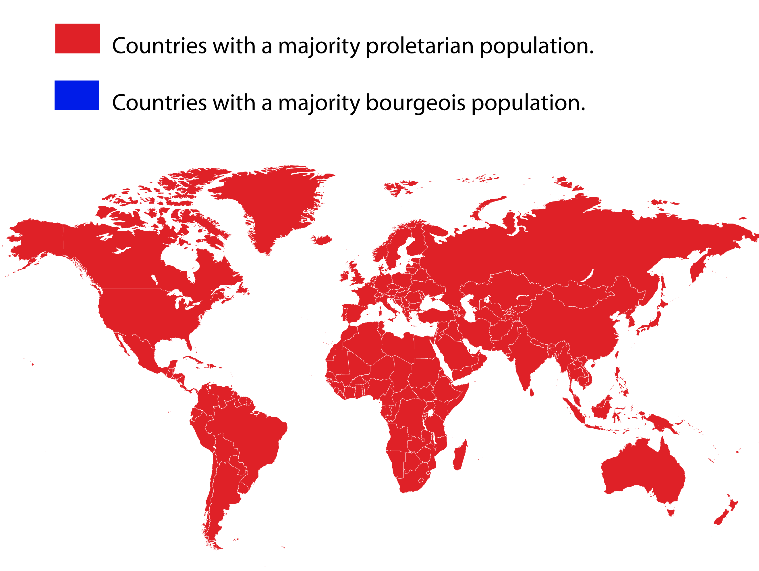
#map #proletariat to fight for #humanrights #humanity #workerrights #future without #oppression #capitalism


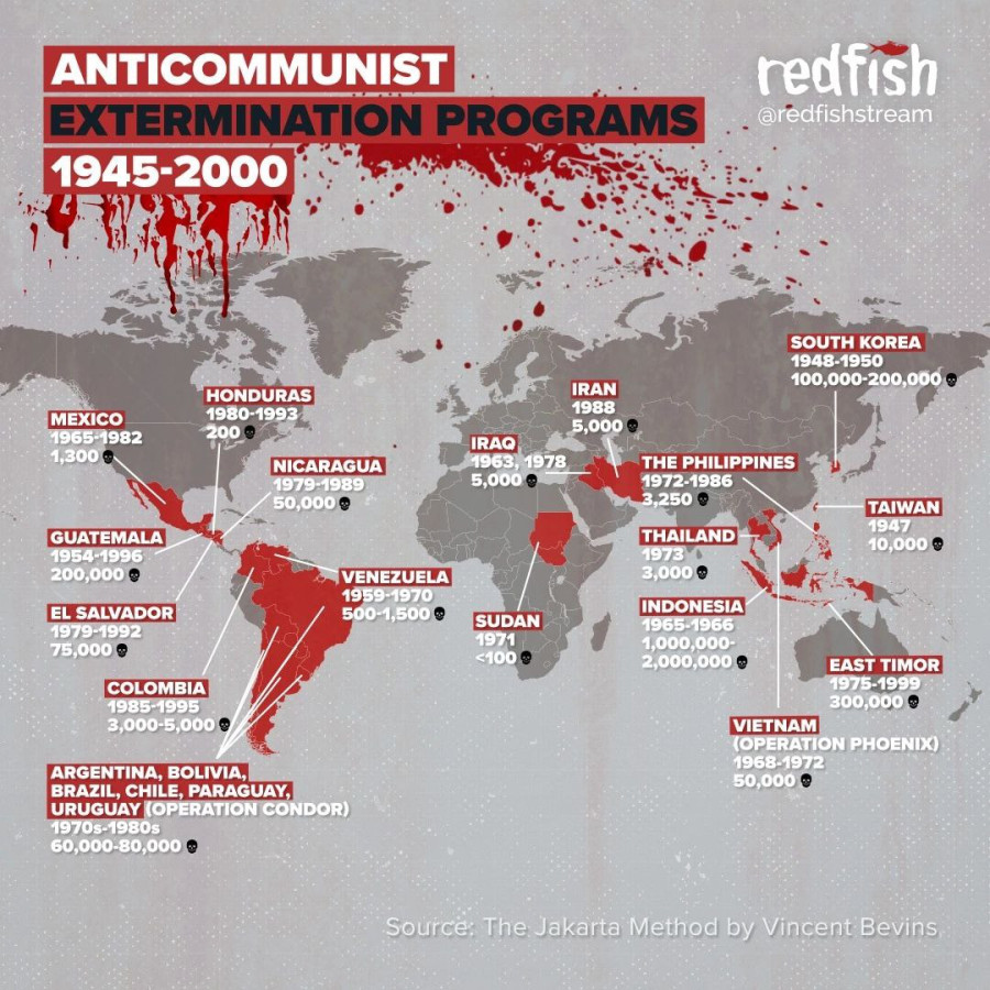
About 1100 Declassified U.S. Nuclear Targets

Declassified lists of nuclear targets in the Eastern Bloc countries, and China in the event of war with the USSR spans 800 pages.
The list includes 179 targets in Moscow, 145 in Leningrad, and 91 in East Berlin, Beijing, and Warsaw.
The most shocking entry in this list is point No. 275—"population": alongside military and industrial facilities, civilian populations in residential areas were also marked for elimination.
https://futureoflife.org/resource/us-nuclear-targets/1100 Declassified U.S. Nuclear Targets - Future of Life Institute
1100 Declassified U.S. Nuclear Targets from 1956 on the interactive NukeMap. Choose a city and a bomb size, and detonate. See what happens.Future of Life Institute

#USA #US #american #Pentagon #military #nuclear #nuclearbomb #map #nukemap #coldwar #Russia #USSR #easterneurope #China #NorthKorea #history

Yogthos (@yogthos@social.marxist.network)
1.52K Posts, 1.34K Following, 4.89K Followers · A sentience trapped in a prison of meat. Made in USSR. Capitalismus delendum est! ☭Yuggoth
👉🏻 https://www.info-res.org/israel-gaza-war/maps/israel-gaza-conflict-map/
Israel-Gaza Conflict Map - Centre for Information Resilience
The Israel-Gaza Conflict Map is a map of incidents documented by CIR covering the Occupied Palestinian Territories, Israel and Lebanon since 7 October 2023.Centre for Information Resilience
More info: https://www.polgeonow.com/2024/12/syria-who-controls-what-2024-rebels-kurds-israel-isil.html
#geography #OSINT #geopolitics #SyriaWar #SyriaNews #MiddleEast #Mediterranean #Russia #maps #mapping #map #cartography #conflictmapping #ArmedConflict #Israel @geography @geopolitics #conflictzones #SyrianCivilWar #Levant
Russia and other countries according to Russians (2019)
https://mapsontheweb.zoom-maps.com/post/189489281501/russia-and-other-countries-according-to-russiansMaps on the Web
Russia and other countries according to Russians. More stereotype maps >>mapsontheweb (Tumblr)

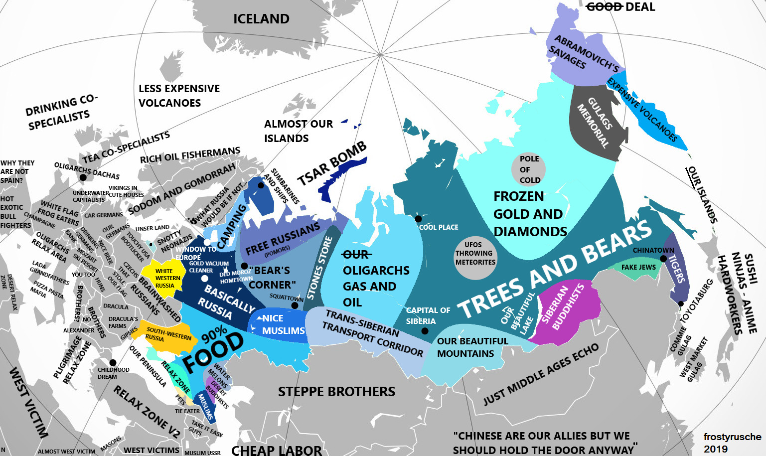
#Russia #map of #russian #stereotypes

OnlMaps (@onlmaps@mastodon.social)
8.27K Posts, 23 Following, 3.12K Followers · Cartography, maps, mapmakers, news on maps, route planners, historical maps from around the world.Mastodon
Shortly after the publication of a United Nations-backed investigation, which accused the Israeli military of war crimes in #Gaza, #POLITICO spoke with four United Kingdom-based health workers who had recently returned from trips to Nasser Hospital in southern Gaza organized by British charity Medical Aid for #Palestinians #MAP They all highlighted the resilience of #Gazans and the local medical staff, but underlined the deepening of exhaustion and desperation
#palestine

Israel ‘methodically destroying’ Gaza, say health workers
Visiting doctors share eyewitness accounts after a U.N. inquiry accused Israel of war crimes by targeting Gaza’s health system.Rory O’Neill (POLITICO)
[…] Israel’s attack on April 1 on the World Central Kitchen convoy, which killed seven workers, far from being an isolated “mistake,” is just one of at least eight incidents that Human Rights Watch identified in which aid organizations and UN agencies had communicated with Israeli authorities the GPS coordinates of an aid convoy or premises and yet Israeli forces attacked the convoy or shelter without any warning.
[…] In these eight incidents, Israeli forces killed at least 15 people, including 2 children, and injured at least 16 others.
2. Attack on a Médecins Sans Frontières (#MSF) convoy, November 18, 2023
3. Attack on a guest house of the United Nations Relief and Works Agency for Palestine Refugees in the Near East (#UNRWA), December 9, 2023
4. Attack on an MSF shelter, January 8, 2024
5. Attack on an International Rescue Committee (#IRC) and Medical Aid for Palestinians (#MAP) guest house, January 18, 2024
6. Attack on an UNRWA convoy, February 5, 2024
7. Attack on an MSF guest house, February 20, 2024
8. Attack on a home sheltering an American Near East Refugee Aid Organization (#Anera) employee, March 8, 2024
https://www.hrw.org/news/2024/05/14/gaza-israelis-attacking-known-aid-worker-locations
@israel #IsraelWarCrimes #Gaza
@palestine

Gaza: Israelis Attacking Known Aid Worker Locations
Israeli forces have carried out at least eight strikes on aid workers’ convoys and premises in Gaza since October 2023, even though aid groups had provided their coordinates to the Israeli authorities to ensure their protection.Human Rights Watch

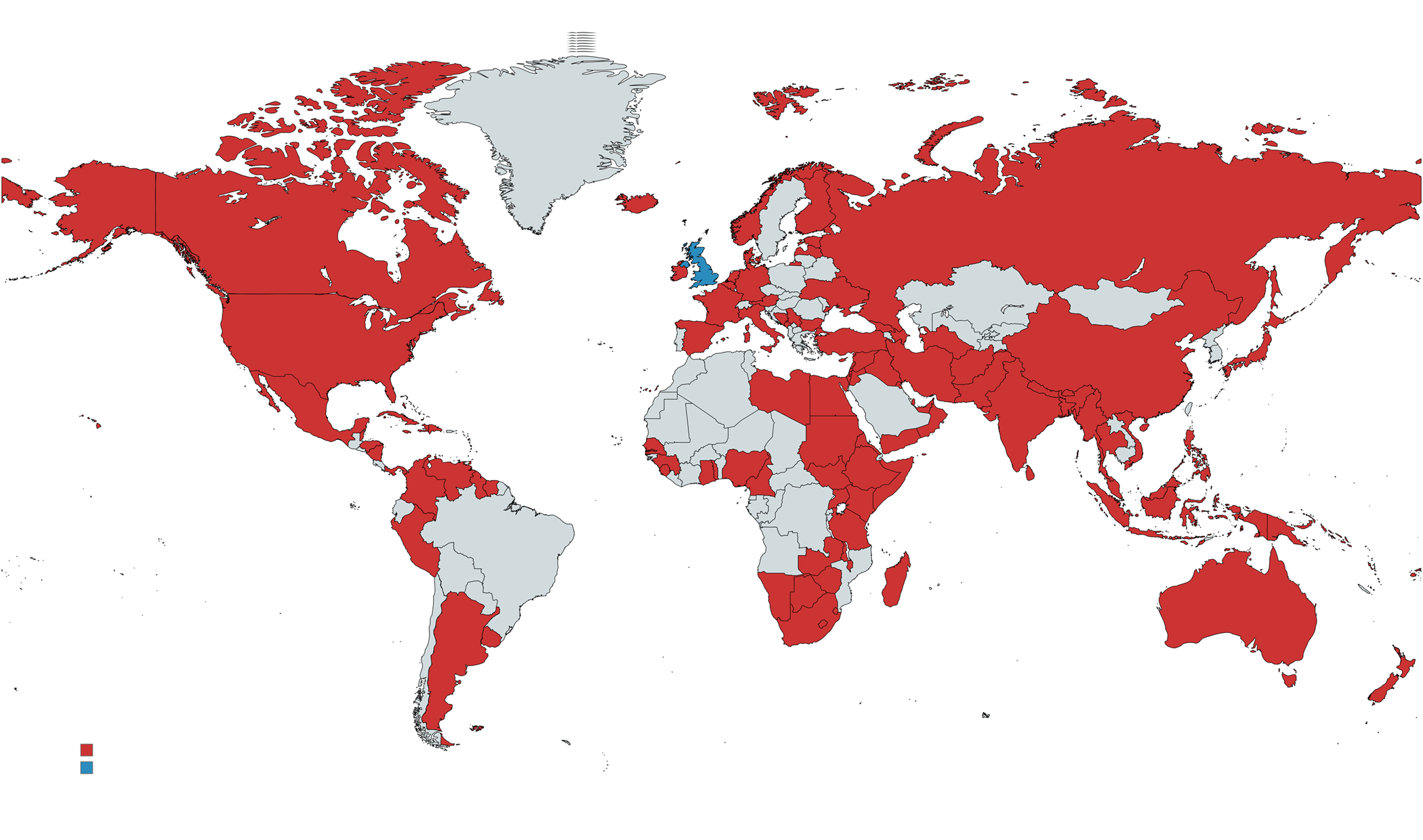
British intervention

(greece) british army engaged in greek civil war (sortly after WWII)..
(koreas) uk also sent troops in korean war, but koreas are not marked red.
#uk #england #map of #british #intervention #colonialism #wars #genocide #history

OnlMaps (@onlmaps@mastodon.social)
6.93K Posts, 24 Following, 2.78K Followers · Cartography, maps, mapmakers, news on maps, route planners, historical maps from around the world.Mastodon
Americans in Ukraine
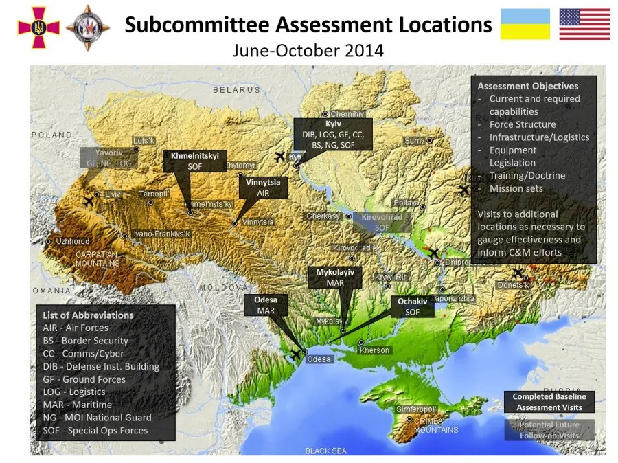
#USA #US #military #NATO #ukraine #ukrainian #AFU #history after #Maidan #map of #american #invasion
SITREP 3/11/24: Patriots Blown Up as Mix-Messaged NATO Fumbles On
Last time we spoke on the sudden upswell of threatening rhetoric booming up from the crumbling sepulcher of Old Europe.Simplicius The Thinker (Simplicius's Garden of Knowledge)

This ‘digital twin’ of the planet could rival Google Earth — here’s how you can try it: Google needs Competition
French startup Kermap has developed a ‘digital twin’ of the Earth that claims to offer the most up-to-date views of our home planet.
The programme is called Nimbo Earth Online and it is the only platform providing new satellite views of the world every month, without clouds. Google Earth refreshes its imagery every several months to years, depending on location.
There’s one caveat though: Nimbo offers a resolution of only 10 metres per pixel. This is far less precise than what is offered by Google Earth.
But then Google Earth has really not been moving forward in leaps and bounds for the last few years. I wanted to find a specific location a few months ago, which contained a shooting range. The problem I had with Google Earth was that more than one of the recent images had cloud concealing that area. Going back in time, went too far back. Nimbo is using AI to remove the clouds. So maybe there is something with this AI-powered mapping.
Nimbo also includes a split & swipe function, which allows you to compare before and after images in one single view.
Although Nimbo states a resolution of 10 m per pixel, the interface has an HD button which says it is coming soon. So, it looks like that will improve.
But this does go to show that Google needs competition in order for them to improve. Google could have already been doing some of this AI-powered mapping if they'd felt the need to.
See This ‘digital twin’ of the planet could rival Google Earth — here’s how you can try itThe new AI-powered platform is the only one of its kind providing new satellite views of the world every month, without clouds.
#technology #mapping #AI

#map #maps #satelliteimagery #earth

This ‘digital twin’ of the planet could rival Google Earth — here's how you can try it
French startup Kermap has developed a ‘digital twin’ of the Earth that claims to offer the most up-to-date views of our home planet. The programme is called Nimbo Earth Online ...Siôn Geschwindt (The Next Web)
Taras Shevchenko, the greatest Ukrainian poet wrote NA Ukraine.

#ukraine #map #language #difference
European de-industrialisation
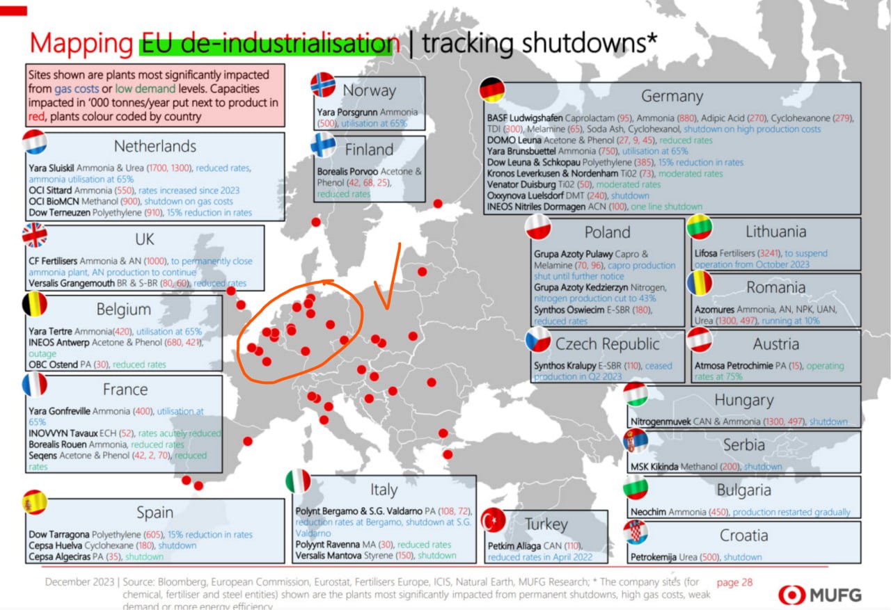
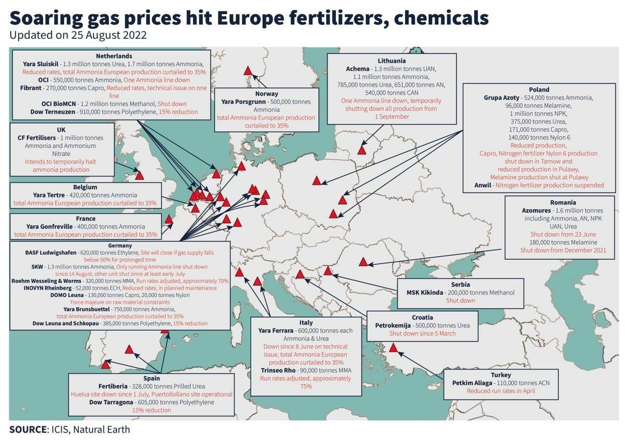
#europe #eu #economy #ukrainisation and #deindustrialisation #future in #poverty by #european #vassalage #energy #hunger #industry #map #nederlands #uk #britain #belgium #france #spain #norway #finland #italiy #germany #poland #czechrepublic #lithuania #romania #austria #hungary #serbia #bulgaria #turkey #croatia

#30DayMapChallenge
Day 14. Europe
Europe's Power Plants


slava (@slava@mstdn.social)
14 Posts, 86 Following, 16 Followers · Humanitarian GIS, IM, and MEALMastodon 🐘


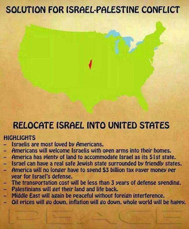
#map of #peace #Israel #Palestine
Israeli Arab Solution--SERIOUSLY!!
Israeli Arab Solution--SERIOUSLY!! https://uploads.disquscdn.com/images/f7b7e2add57f156d08cc7c547dc28febf178e5fedd867826b931533d81ab3ce0.jpgdiaspora* social network
ukrainian counter-offensive
It had been previously stated that the main counter-offensive objective had been downsized to simply taking Tokmak, rather than the unrealistic objectives of capturing Crimea, Mariupol, or even Melitopol. If they can take Tokmak they will be happy and consider that a major success.Almost three months later:
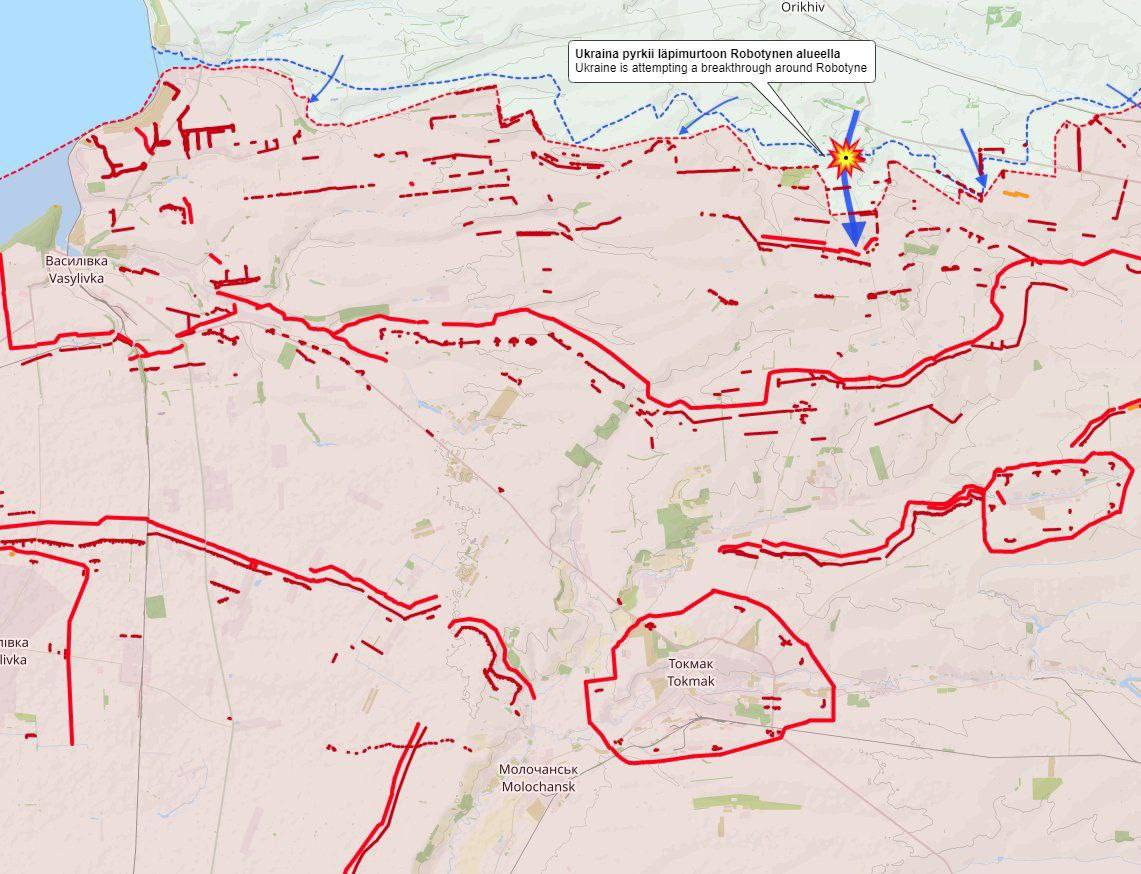
#ukraine #failstate #map #nato #pentagon #fail #western #weapon #military #ukrainian #anti-Russia
SITREP 8/26/23: Wagner Denouement and BRICS Rebirth
Let’s start with the biggest, most momentous update of all. The BRICS summit, which has just ended, ended up in ways surpassing my expectations.Simplicius The Thinker (Simplicius's Garden of Knowledge)