Suche
Beiträge, die mit maps getaggt sind


#NicoleTheFediverseChick #GulfOfMexico #Geography
#Maps #TuckersBalls

#Maps #Afrika #Fake #Literatur
https://de.m.wikipedia.org/wiki/Kong-Berge

Melted ice caps on a vintage Esso gas station map. Higher-res images: https://conspiracyofcartographers.com
#climateChange #maps #cartography #climateCrisis #greenWashing #SouthAmerica #Brazil #Brasil #worldBuilding #Argentina #Colombia #Venezuela #AmazonRiver #Chile #Peru #Ecuador #Paraguay

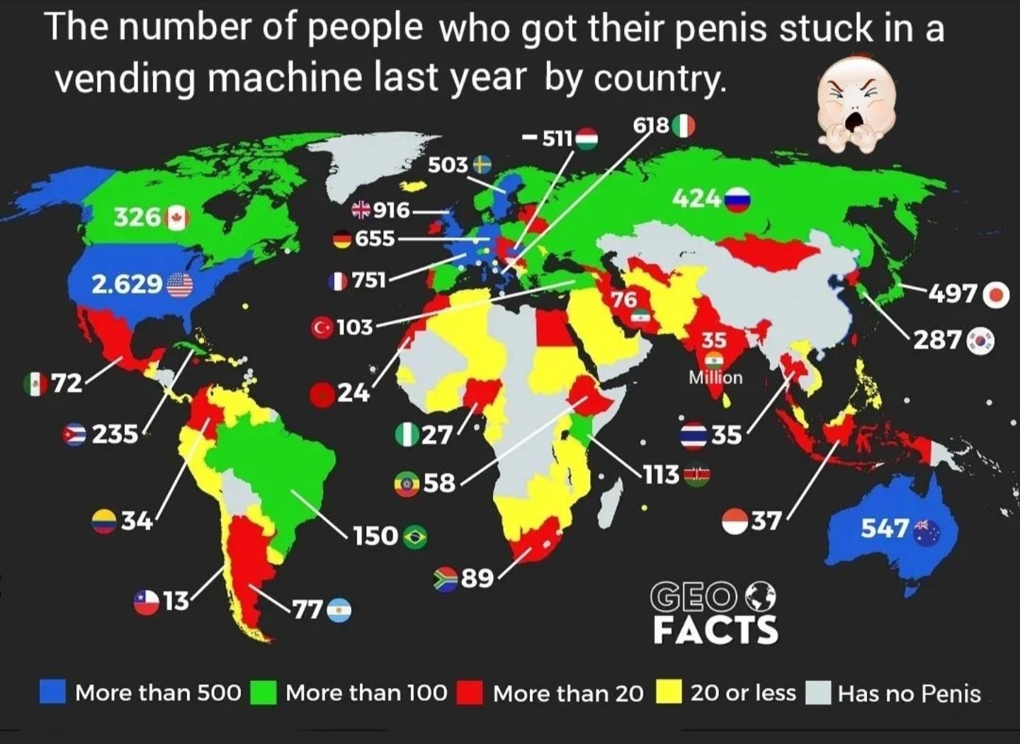
How many people (males and transvestites assumed) got their penis stuck in a vending machine. 2023. Merican Men are #1!
Caveat: The poster claims there's 'nothing wrong with this map', but no methodology is availabe to tell if the numbers quoted are per-capita... nevertheless... 🤣 #maps #funfacts #humor #statistics https://www.reddit.com/r/mapporncirclejerk/comments/1bbm83z/number_of_people_who_got_their_penis_stuck_in_a/

Air Canada apologizes for replacing Israel with the name 'Palestinian territories' on its planes' maps - EUROPE SAYS
This slight didn’t fly under the radar. Air Canada was forced to apologize after it was discovered thatEUROPE SAYS (EUROPESAYS.COM)
https://storymaps.arcgis.com/stories/29fc3a95e8fa4407a96507cc5720609c
"USAID bought $2 billion a year of rice, wheat, lentils, and peas from American farmers. - Civil Eats
Click to see where farmers are getting ruined by MAGA policies and the local political rep to hold accountable."
[It's an interactive map.]
#ElonMusk #Musk #Coup #Doge #Corruption #Trump #GOP #USPol #USPolitics #USAID #Farmers #Food #US #USA #Maps

Farmers ruined by Musk closing USAID
Farmers ruined by Musk closing USAID and who to hold accountableEsri
The problem is just searching for #addresses or named destinations. That's the only reason I use Google Maps. Is there any fix on the horizon?

Syria war live tracker: Maps and charts | Syria's War News - EUROPE SAYS
Here’s what the situation on the ground looks like as of December 11, 2024.In the early hours ofEUROPE SAYS (EUROPESAYS.COM)
https://apnews.com/donate
#journalism #GulfOfMexico #Google #Apple #maps

Donate to the Associated Press
Donate in support of independent, fact-based journalism. For 177 years, The Associated Press has been the most trusted source of fast, accurate, unbiased news.AP News
.
#AmericanAirlines #Aviation #RouteMap #avgeek #maps #Travel #ephemera

#Google #Maps have already made the required changes
#USA #Politics
https://www.bbc.com/news/articles/cn57neepx4vo

Trump says no right of return for Palestinians under Gaza takeover plan
He says his proposed US takeover of Gaza would involve "building a permanent place" for the population.David Gritten (BBC News)

Been using & experimenting with some & I think you might want to find some too.
Apps: https://european-alternatives.eu/category/navigation-apps
https://www.cnbc.com/amp/2025/01/27/google-maps-to-show-gulf-of-america-after-government-updates.html
cc @european_alternatives
#maps #navigation #google #infosec #USpol #location #DataEthics

Mapping 1,800 Israeli settler attacks in the West Bank since October 2023 | Israel-Palestine conflict News - EUROPE SAYS
An average of four incidents of settler violence have taken place each day in the occupied West BankEUROPE SAYS (EUROPESAYS.COM)
Also: Routen bewerten, eintragen, kommentieren, kopieren wären tolle Funktionen.
Mit Organic Maps konnte ich zumindest "Tracks aufzeichen", was ich schon sehr cool fand'.
#komoot #Wandern #opensource #maps #gps #trekking #hiking #organicMaps #osm #openstreetmap

African tribes that were the most taken to The Americas during The Trans Atlantic Slave Trade
African tribes that were the most taken to The Americas during The Trans Atlantic Slave TradePosted by NickiMinajcousinBYTESEU (Bytes Europe)
The publication of maps by the Israeli government claiming areas of Palestine, Jordan, Lebanon, and Syria as part of Israel has been denounced by Gaza ceasefire mediator Qatar.
“We emphasize the necessity for the international community to undertake its legal and moral responsibilities to compel the Israeli occupation to comply with international legitimacy resolutions.”
@palestine
#Israel
#maps
More info: https://www.polgeonow.com/2024/12/syria-who-controls-what-2024-rebels-kurds-israel-isil.html
#geography #OSINT #geopolitics #SyriaWar #SyriaNews #MiddleEast #Mediterranean #Russia #maps #mapping #map #cartography #conflictmapping #ArmedConflict #Israel @geography @geopolitics #conflictzones #SyrianCivilWar #Levant
See more maps of the USSR: https://istorik.net/502-karty-sssr.html #maps #mapstodon
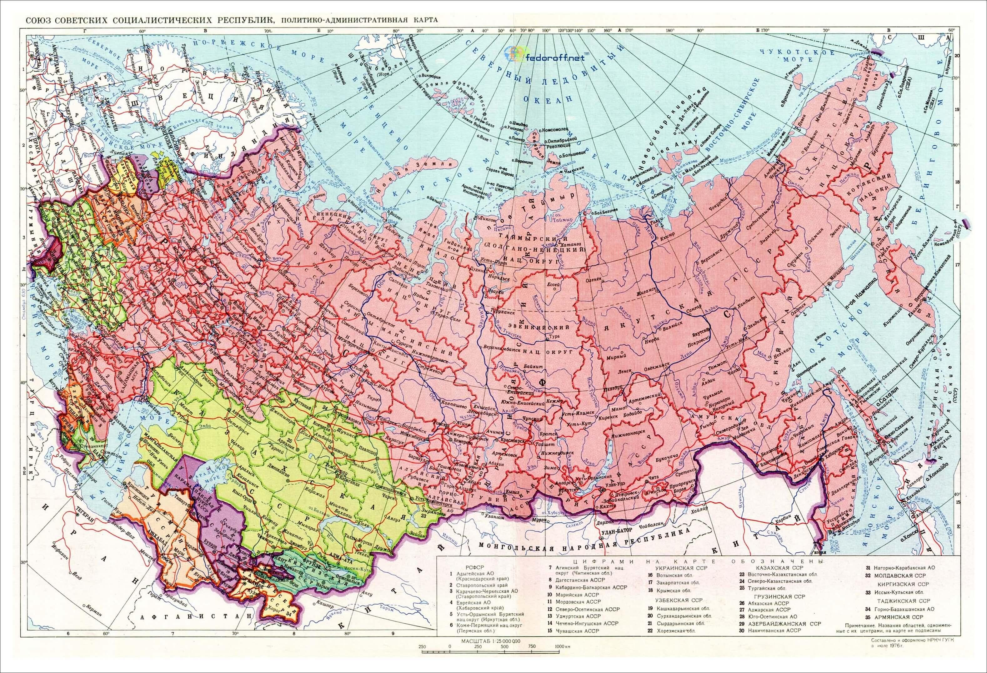
Карты СССР - 1922, 1929, 1937, 1941, 1946, 1976, 1990
Старые карты СССР с подробными границами всех 15 республик СССР от 1922-го по 1990-й показывают, как образовался и выглядел Советский Союз, занимавший 1/7 часть суши Земли.Карта СССР 1922 г.Карта СССР на момент образования, 30 декабря 1922 г.Исторические события мира XIX, XX, XXI века | Историк (istorik.net)
 above a print of train stop names along multi-colored lines")


This ‘digital twin’ of the planet could rival Google Earth — here’s how you can try it: Google needs Competition
French startup Kermap has developed a ‘digital twin’ of the Earth that claims to offer the most up-to-date views of our home planet.
The programme is called Nimbo Earth Online and it is the only platform providing new satellite views of the world every month, without clouds. Google Earth refreshes its imagery every several months to years, depending on location.
There’s one caveat though: Nimbo offers a resolution of only 10 metres per pixel. This is far less precise than what is offered by Google Earth.
But then Google Earth has really not been moving forward in leaps and bounds for the last few years. I wanted to find a specific location a few months ago, which contained a shooting range. The problem I had with Google Earth was that more than one of the recent images had cloud concealing that area. Going back in time, went too far back. Nimbo is using AI to remove the clouds. So maybe there is something with this AI-powered mapping.
Nimbo also includes a split & swipe function, which allows you to compare before and after images in one single view.
Although Nimbo states a resolution of 10 m per pixel, the interface has an HD button which says it is coming soon. So, it looks like that will improve.
But this does go to show that Google needs competition in order for them to improve. Google could have already been doing some of this AI-powered mapping if they'd felt the need to.
See This ‘digital twin’ of the planet could rival Google Earth — here’s how you can try itThe new AI-powered platform is the only one of its kind providing new satellite views of the world every month, without clouds.
#technology #mapping #AI

#map #maps #satelliteimagery #earth

This ‘digital twin’ of the planet could rival Google Earth — here's how you can try it
French startup Kermap has developed a ‘digital twin’ of the Earth that claims to offer the most up-to-date views of our home planet. The programme is called Nimbo Earth Online ...Siôn Geschwindt (The Next Web)