Suche
Beiträge, die mit OpenStreetMap getaggt sind
I'm a transfem (possibly also neurodivergent) sysadmin maintaining infrastructure and creating content at TechTransThai while also being a member of openKMITL, OpenTechSummit Thailand and other communities.
I'm interested in the Linux ecosystem (mostly GNOME, KDE, gaming, servers and containerization), DevOps stuff, OpenStreetMap, BOINC and open source software in general.
#introduction #trans #neurodivergent #FOSS4Change #openKMITL #TechTransThai #Linux #OpenStreetMap #DevOps #Containers #BOINC #OpenSource

https://www.kom-in.de/170/openstop-haltestelle-an-der-datenautobahn
Es gibt auch nen lebendigen #Matrix Raum zu #OpenStreetMap #osm

OpenStop - Haltestelle an der Datenautobahn?
Die Erfassung von Daten zur Barrierefreiheit von Haltestellen des öffentlichen Verkehrs ist notwendig.www.kom-in.de
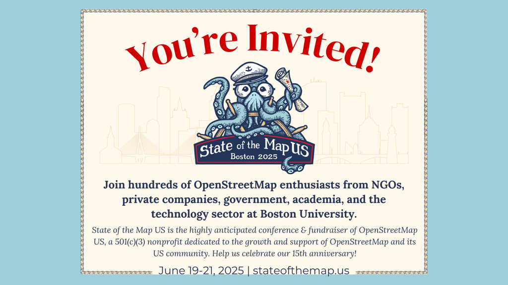
The Call for Participation is now open! Submit your talk today!
https://2025.stateofthemap.org/calls/general/
#OpenStreetMap #OSM #gischat #sotm #sptm2025 @sotm
State of the Map 2025 – Manila
The global OpenStreetMap conference. 2025 in Manila & online.2025.stateofthemap.org
Persönlich bin ich nie mit #Komoot warm geworden – aber die Umfrage hat gezeigt: Es gibt viele valide Anwendungsfälle! Manche schätzen die Community-Fotos, andere die einfache Bedienung oder das Archiv. Jeder hat andere Bedürfnisse und Komoot bedient viele davon.
Für mich war das Routing nie überzeugend, und ich bevorzuge #Bikerouter oder #OpenStreetMap. Aber ich verstehe jetzt besser, warum andere Komoot mögen – es ist eine Art „All-in-One“-Lösung, die für viele funktioniert. 🚴
Zusammenfassung:
#Komoot wird oft als „Gesamtpaket“ genutzt – kein Feature allein hat sich besonders in den Vordergrund gedrängt
Stärken:
Community-Inhalte, einfache Handhabung, Offline-Karten
Schwächen:
Routing, veraltete Features, Premium-Wall
Ersatz (zumindest teilweise) möglich durch Kombi aus OSM-Tools (#Bikerouter), gesonderte GPX-Verwaltung (lokal oder im Netz) und Social-Media-ähnlichen Plattformen (z.B #OpenStreetMap-Communities)
Vielen herzlichen Dank an alle Antwortenden! 🚴
Kategorie 1: Community & Inspiration
1. Trailview-Fotos (automat. Wegbilder z. B. Schotter/Sand)
2. Öffentliche Touren-Sammlungen als Vorlage
3. POI-Bewertungen („Aussichtspunkt lohnt sich“)
4. Teilen von Touren mit Freunden/Community
5. Folgen von Nutzenden mit ähnlichen Interessen
Alternative: Fotos/POIs lassen sich über #OpenStreetMap, #uMap + Wikis wie WaymarkedTrails abbilden, aber weniger zentralisiert.
This already sucked when Facebook was doing it and it being “open source” doesn’t do anything to mitigate the actual harmful impact 🤷 (seems that the “commit to OSM” at least was turned off for now, thanks @grischard!)
https://blog.mozilla.ai/map-features-in-openstreetmap-with-computer-vision/

Map Features in OpenStreetMap with Computer Vision
Mozilla.ai developed and released the OpenStreetMap AI Helper Blueprint. If you love maps and are interested in training your own computer vision model, you’ll enjoy diving into this Blueprint.David de la Iglesia Castro (Mozilla.ai)
Das System ist immer das gleiche!
#User bezahlen für eine App wie #Komoot Xy € und füttern diese #kostenlos mit Inhalt.
Dann werden die #Daten verkauft....
Nehmt #opensource Alternativen rund um #openstreetmap wie #organicMaps, #osmand und viele mehr
Diese #tracken auch nicht und der #Datenschutz ist wesentlich besser!
#Daten #digitalcourage #digitalzwang #Betrug

🦞 Whether you’re brand new to open mapping or an OpenStreetMap veteran, this conference is for you.
🔗 https://buff.ly/ISMd0D0
#TicketTuesday #StateoftheMapUS #OpenStreetMap
State of the Map US 2025
The 13th State of the Map US will be held in-person at Boston University in Boston, Massachusetts June 19-21, 2025. ***TICKET TIERS ARE AS FOLLOWS*** Academic & Nonprofit Admission: Strictly for full time students, educators and nonprofit staff.OpenStreetMap US
1000+ (Eintausend) Leute auf der #Fedikarte . DANKE 🥰👍
Wie... Kennst du noch nicht? Eine Karte, auf der sich Leute aus dem Fediverse selbstständig ein oder austragen können. Keine KI, sondern ein liebevoll programmierter Bot von @wolfmond . Karte auf Basis von OpenStreetMap, alle Daten (bis auf die Kartenkacheln) selbst gehosted.
Alle Infos zum Projekt (und die Karte 🥰) unter https://fedikarte.de
#GemeinsamStattEinsam
#Fediversum
#Fedikarte
#Opensource
#OSM
#OpenStreetMap

Avez-vous une astuce pour les filtrer ?

The problem is just searching for #addresses or named destinations. That's the only reason I use Google Maps. Is there any fix on the horizon?
ich suche nach eine Webanwendung, mit der ich Marker auf eine Map setzen kann. Zu diesem Marker soll man dann eine Beschreibung setzen können. Pro Marker soll man Bilder hochladen können, die als "Diashow" durchgeschaut werden können.
Es soll foss sein und auf osm basieren.
Am nächsten kommt da uMap ran. Leider ist die Bildintegration nicht so dolle, weil man einzelne URLs zum eigentlichen Bild eintragen muss.
#foss #osm #openstreetmap
1/
Zwecks Umstellungserleichterung für die Mitarbeity gern möglichst Google Maps ähnlich.
Edit:
Autonavigation ist in diesem Fall gemeint.
#unplugtrump
Bin gespannt auf Feedback!
Karte | fahrrad.dev
Deine Stadt, Dein Dorf - Deine Fahrradkarte. Finde Radrouten, Radwege, Fahrradparkplätze, Reparaturstationen und mehr in deiner Nähe. Komme einfach schnell von A nach B im Alltag.fahrrad.dev


#map #oepnstreet #openstreetmap #karte #gpogle #googlemaps
Mir war bisher nur "OsmAnd" sowie "Organic Maps" bekannt in dem Kontext. Letzteres benutze ich beständig um meine täglichen Spaziergänge ordentlich zu verfolgen, was sehr gut sowie genau funktioniert. 😁
#OrganicMaps #OsmAnd #OpenStreetMap
@roblen
Statt Google Maps nutze OpenStreetMap. Es gibt zahlreiche Websites und Apps, die auf den Daten dieses Communityprojekts basieren: Einfache, trackingfreie Apps sind MagicEarth und Organic Maps. Anspruchsvolle nehmen gerne OsmAnd. GraphHopper bietet schnelle Routenberechnung. BRouter-Web ist ideal zum Planen von Freizeitaktivitäten mit vielen Einstellungsmöglichkeiten.
#OpenStreetMap #MagicEarth #OrganicMaps #OsmAnd #BRouter #MapsAlternative #datenschutz #privacy

I have to ask astupid question: Are there actually OSM maps with longitude and latitude grids?
#OpenStreetMap
📣 Ich bin heute von meinem altehrwürdigen Mastodon-Account @caos@metalhead.club auf diesen Account nach #Sharkey umgezogen. Bin also mehr nicht ganz #NeuHier im #Fediverse .
Mit diesem Account hier geht es dann auch weiter u.a. um
- 🎸 #Musik (#Punk #Rock #Metal #Indie #Darkwave)
- Regionales: #Köln #Wuppertal 🚟 #NRW
- #Sport #Tischtennis 🏓
- #Verkehrswende #ÖPNV 🚋
- #Umfragen 📊
Weiterhin gibt es noch caos auf #Friendica mit @caos@anonsys.net :
Schwerpunkte dort sind u.a. #FOSS #Datenschutz #Fediverse #Linux #OpenStreetMap #CustomROM #DeGoogle #FDroid
Schaut bei Interesse gerne auch in die Gruppen und Foren im Fediverse, die ich moderiere:
🎸 Forum "Rockdisco Exit" #Solingen: @exit_revival@anonsys.net #Umfragen #AskExit #90sMusic: @AskExit_Rockdisco@mk.absturztau.be
🚟 Wuppertal-Community: @wuppertal@feddit.org
❤ 🤍 Köln-Gruppe: @koeln@anonsys.net
🏓 Tischtennis-Community: @tischtennis@feddit.org
🟢 FOSS-Community: @foss_de@feddit.org
🔐 Datenschutz-Community: @datenschutz@feddit.org


🚨 Ich ZIEHE heute UM mit diesem Account nach #Sharkey 🦈 zu plasmatrap.com mit 👉 @caos@plasmatrap.com
Dort geht es dann auch u.a. um 🎸 #Musik (#Punk #Rock #Metal #Indie #Darkwave) + #Köln #Wuppertal 🚟 #NRW + #Sport #Tischtennis 🏓 + #Verkehrswende #ÖPNV 🚋
Weiter gibt es caos auf #Friendica mit @caos@anonsys.net :
Schwerpunkte dort sind u.a. #FOSS #Datenschutz #Fediverse #Linux #OpenStreetMap #CustomROM #DeGoogle #FDroid
🙏 vielen Dank an @thomas !! Die metalhead-Instanz ist top 👍 , nur für mich passt Mastodon nicht so richtig gut. Rock on 🤘

Der #BKG weltweite Vektorkacheldienst erhielt im Januar 2025 aktualisierte OpenStreetMap-Daten. Innerhalb Deutschlands bleibt der Datenstand identisch zur basemap.de Web Vektor, die monatlich aktualisiert wird.
Nächste Aktualisierung der internationalen Daten: Anfang Juli 2025!
Mehr Infos gibt’s hier: https://basemap.de/produkte-und-dienste/web-vektor-world/
#basemapWorld #Geodaten #WebVektor #Kartographie #OpenStreetMap

An #OpenSource #Navigation app for #Android using #OpenStreetMap data.
Pretty cool, minimalist but the routing is very fast, it has multiple routing profiles including special ones like bike with terrain, hiking etc.
And it supports some cool map styles!
Navigation is experimental, but the #gpx Track can also be used in #OSMAnd
#FOSS #OSMAndMaps


I'm #danish and speak #german and #english as well. If anyon has tips for mastodon, please shoot them at me.
#introduction
Google Maps: Aus dem ‚Golf von Mexiko‘ wird der ‚Gulf of America‘ – Google wird das Trump-Dekret umsetzen - GoogleWatchBlog (Jens) https://www.googlewatchblog.de/2025/01/google-maps-aus-dem-golf-von-mexiko-wird-der-gulf-of-america-google-wird-das-trump-dekret-umsetzen/

Google Maps: Aus dem 'Golf von Mexiko' wird der 'Gulf of America' - Google wird das Trump-Dekret umsetzen
Das ist nicht ganz überraschend, aber wird dennoch diskutiert: Google Maps wird den Golf von Mexiko in Golf von Amerika umbenennen.Jens (GoogleWatchBlog)
#gpxstudio #cycling

Zumindest rund um meine Lieblings Ladesäulen.
Naja was tun in den 20 Minuten, in denen die Karre Lädt?
Mappen!
Was ich schon an Hydranten, Laternen und Bäume eingetragen habe...
Demnächst noch Parkplätze, Straßenschilder, die ganzen Firmen etc...
#OpenStreetMap
#thunderbird
#osmand
#internetarchive
#wikipedia
The last 2 are not Free & Libre Open Source Software, but they are for the #OpenCommons and that's close enough for me. We can argue the finer points if you like : )
Audio guide when to turn, take highway exit, etc..
#openstreetmap
#degoogle
#mapstodon #mapping #openstreetmap
Also: Routen bewerten, eintragen, kommentieren, kopieren wären tolle Funktionen.
Mit Organic Maps konnte ich zumindest "Tracks aufzeichen", was ich schon sehr cool fand'.
#komoot #Wandern #opensource #maps #gps #trekking #hiking #organicMaps #osm #openstreetmap
This is my first video about it https://youtu.be/zWrDM1fZEnU?si=2W-XhIMkUKMfHux1
Bringing OpenStreetMap Data Into Minecraft

Over the years, dedicated gamers have created incredible recreations of real (and not so real) locations and structures within the confines of Minecraft. Thanks to their efforts, you can explore everything from New York City to Middle Earth and the U.S.S. Enterprise in 1:1: scale.
But what if you wanted to recreate your own town, and didn’t have the hundreds of hours of spare time necessary to do it by hand? Enter Arnis, an open source project from [Louis Erbkamm] that can pull in geographic data from OpenStreetMap and turn it into a highly detailed Minecraft map with just a few keystrokes.
Once generated, the map can be loaded into the Java Edition of Minecraft. This refers to the original build of the game that predates the Microsoft buyout.
Looks like a pretty interesting holiday project!
See https://hackaday.com/2024/12/30/bringing-openstreetmap-data-into-minecraft
#Blog, #gaming, #minecraft, #OpenStreetMap, #technology